Pawnee Rock.—This historic landmark is located in the southwest corner of Barton county and is distant about 100 yards from the old Santa Fe trail. The rock is at the southern extremity of a bluff that extends several miles in a northwesterly direction from the Arkansas river. It overlooks the country in the valleys of the Arkansas, Ash and Walnut for many miles. It is less than a mile distant from the town of Pawnee Rock. Originally the rock was much larger than at present, a great deal of stone having been taken from it and made use of by settlers. During the period of the Santa Fe trade this rock was a favorite stopping place for travelers, the rock affording an ideal protection against hostile Indians. According to Henry Inman, the name was given the rock on account of a fight with Pawnee Indians in which Kit Carson took part. Cutler's History of Kansas says the name attached from the fact that the various tribes of Pawnees met in general council on the top of it.
The Woman's Kansas Day club became interested in the preservation of this landmark, and through their efforts Benjamin P. Unruh, on May 25, 1908, executed a deed, his intention being to convey to the state 5 acres of land on which Pawnee Rock was located. By a mutual mistake the description of land in the deed fixed the location at 380 feet too far north, and on June 29, 1909, Mr. Unrnh and his wife executed a new deed to the state for the purpose of correcting the error in the former one. The description of the tract is now as follows: "Commencing at a point 2,290 6-10 feet north of the northeast corner of block 3 in the city of Pawnee Rock, on the west side of the extension of Center street in said city and running thence west 465 feet, thence north 380 feet, thence east 465 feet, and thence south 380 feet to the place of beginning, said land adjoining on the north the certain 5-acre tract conveyed by the said Benjamin P. Unruh to the State of Kansas by deed dated June 29, 1909, and recorded at page 371 of volume 47 of the deeds and records in the office of register of deeds of Barton county, Kansas."
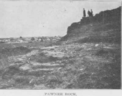
PAWNEE ROCK.
To correct the above error Representative William P. Feder of Barton county in the legislature of 1911 introduced House Joint Resolution No. 11 which authorized the state to execute a deed in favor of Mr. Unruh conveying to him the 5 acres erroneously deeded.
The legislature of 1909 passed an act making an appropriation for the expenses of keeping up and maintaining the historic spot of Pawnee Rock. The act provided for the appointment of a board of trustees under whose management and direction the appropriation of $500 was to be expended during the ensuing two years. A provision in reference to a roadway to the park was made. The legislature of 1911 also made provision for the care of the site.
Pages 455-457 from volume II of Kansas: a cyclopedia of state history, embracing events, institutions, industries, counties, cities, towns, prominent persons, etc. ... / with a supplementary volume devoted to selected personal history and reminiscence. Standard Pub. Co. Chicago : 1912. 3 v. in 4. : front., ill., ports.; 28 cm. Vols. I-II edited by Frank W. Blackmar. Transcribed July 2002 by Carolyn Ward.
![]()
TITLE PAGE / LIST OF ILLUSTRATIONS
INTRODUCTION
A | B | C | D | E | F | G | H | I
VOLUME II
TITLE PAGE / LIST OF ILLUSTRATIONS
J | K | L | Mc | M | N | O | P | Q | R | S | T | U | V | W | X | Y | Z
VOLUME III
BIOGRAPHICAL INDEXES
