| 1918 KANSAS AND KANSANS | Chapter 10 | Part 11 |
The Ottawas were found on the Georgian Bay by Champlain in 1615. They seem to have been a people who traded much with other tribes. They had developed a commerce in tobacco, medicinial herbs and roots, rugs, mats, furs and skins, cornmeal, and an oil made of the seeds of the sunflower. They were in close alliance with the Hurons, or Wyandots, from the first. And the Wyandots raised tobacco for the Indian trade.
The history of the Ottawas runs much like that of the other tribes found along the Great Lakes. They claim that they owned the country through which flowed the Ottawa River, in Canada. They were pushed westward. They lived in 1635 on Manitoulin Island. They were at war with the Iroquois, and fled from these fierce children of the League. With the Wyandots, they found themselves about Detroit, where their chief and greatest warrior, Pontiac, formed a confederacy and made war on the English. The war was not successful because of the peculiar disposition of the Indians. The Ottawas were always a factor in the wars waged by the Indians against the advancing settlers. On the 26th day of September, 1833, the Ottawas ceded their lands on the west shore of Lake Michigan for a reservation in the country which was to become Kansas. This treaty was made by only a portion of the tribe, which was, and is to this day, widely scattered The Ottawas of Blanchard's Fork were to have thirty-four thousand acres, and those of Roche de Boeuf were to have forty thousand acres. This land was laid off in a single tract, which contained seventy-two thousand acres. It was on the Marais des Cygnes River, and the City of Ottawa, Kansas, is located about the center of the reservation. The Ottawas settled on their new land in 1837 (a few arrived in 1836), and there were arrivals for some years later.
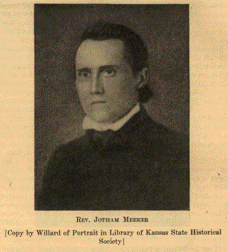 REV. JOTHAM MEEKER [Copy by Willard of Portrait in Library of Kansas State Historical Society] |
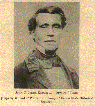 JOHN T. JONES, KNOWN AS "OTTAWA" JONES [Copy by Willard of Portrait in Library of Kansas State Historical Society] |
The Baptists founded a mission among these Ottawas. Rev. Jotham Meeker had labored among those of the tribe in Michigan. In 1837 he was at the Shawnee Baptist Mission. When Rev. John G. Pratt came to the Shawnee mission, Mr. Meeker went on to the Ottawas, arriving in June, 1837. Buildings were erected on what is now the northwest quarter of section twenty-eight (28), township sixteen (16), range twenty (20). They stood on the south side of Ottawa Creek directly east of the present town of Ottawa. All the buildings put up there must have been of temporary character, for they had entirely disappeared before 1866. The old cemetery is still preserved. Meeker died at the mission January 11,1854. Mrs. Meeker died March 15, 1856. Both are buried in the old cemetery. The church which they founded was presided over by John T. Jones, known as "Ottawa" Jones, a half-blood Ottawa, who had been educated at Hamilton, New York. The printing press which had been installed at the Shawnee Baptist Mission was moved to the Ottawa mission, where many books for use among different tribes were printed. This was the first printing press brought to the country which became Kansas. G. W. Brown bought it of Mr. Meeker, and used it in the office of the Herald of Freedom, at Lawrence. S. S. Prouty bought it from Brown, and used it to print Freedom's Champion, at Prairie City. It was then taken to Lecompton and used in the office of Solomon Weaver. From Lecompton it was taken to Cottonwood Falls, and from thence to Cowley County, finally going into the Indian Territory. The type used at the mission was scattered over the prairie by the Indian children. The press was a Seth Adams press. There were twenty stars on it, indicating that it was made in 1817, when the Union contained twenty states.
The Ottawas left Kansas in 1870, going to the Indian Territory. On June 24, 1862, they had made a treaty disposing of their lands. The land-shark stood by to despoil the Indian. There is not a more miserable story in all land transactions than that of the Ottawa reserve.
The Miamis were called Twightwees by the Early English writers. They were sometimes spoken of as the Crane people. Little Turtle, their chief, replied when asked the bounds of his country by "Mad" Anthony; "My forefather kindled the first fire at Detroit; from thence he extended his line to the headwaters of the Scioto; from thence to its mouth; from thence to the mouth of the Wabash; and from thence to Chicago, on Lake Michigan. These are the boundaries within which the prints of my ancestors' houses are everywhere to be seen."
The Miamis were an important tribe in the Ohio Valley, where they bore a part in all the border wars. They are of the Algonquian stock and have the social organization of that family. There are ten clans in the tribe:
| 1. | Wolf. |
| 2. | Loon. |
| 3. | Eagle. |
| 4. | Buzzard. |
| 5. | Panther. |
| 6. | Turkey. |
| 7. | Raccoon. |
| 8. | Snow. |
| 9. | Sun. |
| 10. | Water. |
By the time of general treaty-making to divest the Indians of their land east of the Mississippi, the Miamis were mostly in Indiana. By the treaties of 1839 and 1841 they were possessed of a reservation adjoining the State of Missouri, immediately north of the land of the New York Indians, south of the country of the Weas, and east of the Pottawatomies. Miami County was made from a portion of this reservation. They arrived and began a settlement on Sugar Creek in 1846. By the end of 1847 there were eleven hundred of them on their reservation, but half of them died the following year. Many of them returned to their old homes east of the Mississippi. The remainder moved to the Marais des Cygnes, in the south part of Miami County, where they established what was called Miami Village. The Baptists and Catholics had missions among the Miamis in Kansas.
The Miami reservation contained about five hundred thousand acres. The land was as good as can be found in Kansas. The land-stealers soon came to demand it. A treaty was concluded June 5, 1854, by which the reservation was sold to the United States for two hundred thousand dollars. There was excepted a tract containing seventy-two thousand acres. This tract was later secured by the white settlers by the usual methods in use for getting possession of Indian land. In 1871 the Miamis removed to a reservation on the Spring River, in what is now Oklahoma.
The Chippewas are one of the largest of the Algonquian tribes. The correct form of the name is Ojibwa. It signifies "to roast till puckered up" and has reference to the puckered seam in their moccasins, it being peculiar to the tribe, no others making the moccasin in that way.
The original territory occupied by this tribe bordered both shores of Lake Huron and Lake Superior, and extended westward to the Turtle Mountains, in North Dakota. This land was beyond and beside the trails and courses of the first settlers, and as a consequence the Chippewas were not embroiled in so many of the border wars as were other tribes less fortunately situated.
The Chippewas, as did many other Indian nations, became widely scattered as a result of the settlement of the country by Europeans. A number of small bands settled and remained about Lake St. Clair. The band on the Swan Creek of that lake came to be known as the Swan-Creek band. The Black River flows into Lake St. Clair, and the band living on that stream came to be called the Black-River band. By a treaty made May 9, 1836, these bands ceded their lands on the stream named, and were guaranteed a reservation west of the Mississippi of eight thousand three hundred and twenty acres. This tract was finally located a few miles west of Ottawa, in Franklin County, Kansas. Only a few families were settled on these lands. To these the whole reservation was given. By the terms of the treaty made July 16, 1859, the Munsee or Christian Indians were united with these Chippewas and made joint owners of the reservation. This band was composed of the Christian Indians of the Munsee tribe, and this tribe has had notice in our account of the Delawares. In the treaty of 1859 provision was made for allotment of lands in severalty. In the course of time this was done. In 1871 the surplus land was sold. The Chippewas then asked that they be permitted to sell all their lands and move to the Indian Territory. This was complied with, but the process was slow. It was 1901 before the transaction was completed and the Indians received the proceeds of the sales of their lands.
There was a Moravian mission among these Indians. Little was ever accomplished in the way of Christianizing the Chippewas, however. Their missionary once remarked that he had little hope of meeting any of them in heaven.
| 1. | Wolf. |
| 2. | Bear. |
| 3. | Beaver. |
| 4. | Mud Turtle. |
| 5. | Snapping Turtle. |
| 6. | Little Turtle. |
| 7. | Reindeer. |
| 8. | Snipe. |
| 9. | Crane. |
| 10. | Pigeon Hawk. |
| 11. | Raven. |
| 12. | Bald Eagle. |
| 13. | Loon. |
| 14. | Duck. |
| 15. | Swan. |
| 16. | Snake. |
| 17. | Marten. |
| 18. | Heron. |
| 19. | Bullhead. |
| 20. | Carp. |
| 21. | Sturgeon. |
| 22. | Pike. |
| 23. | Pickerel. |
Another small band of the Christian Indians moved to Kansas and were permitted to settle on the Delaware reservation. They had a town near the Kansas River, near the present town of Muncie, in Wyandotte County. Later they moved to a beautiful location in Leavenworth County, now the National Military Home and Mount Muncie Cemetery. A small band of Stockbridges had been permitted to settle there, also, but these returned to Wisconsin after a residence of a few years. In the treaty of May 6, 1854, with the Delaware, the Moravian Munsees, called also the Christian Indians, were assigned a reservation. It included the fine location mentioned above, and consisted of four sections of land. They lived on their reservation but four years after it had been set off to them. By act of Congress they were authorized to dispose of the land, and they sold it to one A. J. Isacks.
This was not a true confederacy, but an association of tribes which resulted from circumstances over which none had much control.
The Kaskaskias made a treaty at Vincennes in 1803, in which it is recited that they "are the remains, and rightfully represent all the tribes of the Illinois Indians." They ceded more than eight million acres in the heart of Illinois, reserving only three hundred and fifty acres near the old town of Kaskaskia, with the privilege of locating another tract of twelve hundred and eighty acres in the tract ceded. In 1818 the Peorias, part of the Illinois Indians, who had to that time lived apart, united with the Kaskaskias. All of them ceded their lands in Illinois and received a reservation of six hundred and forty acres on the Blackwater River, near St. Genevieve, in Missouri. The Weas and Piankashwas were closely related to the Miamis. They ceded their lands in Indiana in 1818 - the Piankashwas earlier - and were moved west of the Mississippi in that year. They were settled near St. Genevieve, also. There these tribes became united with the Kaskaskias and Peorias. But, like the Delawares and Shawnees, they wandered at will in the West. The existence of Peoria and Piankashaw towns on the White River, near the site of the present town of Forsyth, Mo., has been noticed. These towns had been established before 1828. October 27, 1832, a treaty made with the Kaskaskias and Peorias assigned them one hundred and fifty sections of land west of the State of Missouri, on the waters of the Osage River. This reservation was to include a Peoria town which had already been established on the north bank of the Osage, or Marais des Cygnes, a few miles below the present site of Ottawa, Franklin County. The Peorias had arrived in 1827.
On the 29th day of October, 1832, the Piankashaws and Weas were given a reservation extending from that of the Kaskaskias and Peorias to the west line of the State of Missouri, containing two hundred and fifty sections of land. These reservations were in what are now Franklin and Miami counties.
In the treaty made on the 30th day of May, 1854, it is recited "that the tribes of Kaskaskia and Peoria Indians, and the Piankeshaw and Wea Indians, having recently in joint council assembled, united themselves into a single tribe, the United States hereby assent to the action of said joint council. "In this treaty it was provided that the lands should be allotted to the Indians and the surplus land sold for their benefit. Baptiste Peoria was accused of having secured proceeds of the sales of land allotted to pretended parties, who did not exist. The fraud caused many lawsuits. These Indians were settled at the Quapaw Agency, in the Indian Territory.
The Presbyterians established a mission among the Weas and Piankashwas. It was commenced in 1834, and seems to have been abandoned in 1838. The Methodists had a mission among the Peorias about the same time. The Baptists established a mission about one mile east of the present town of Paola, and the mission prevailed and prospered. It was commenced about the year 1839. Dr. David Lykins was the missionary in 1844, and he continued to live in that country after the Territory of Kansas had been organized. In some authorities it is said that Dr. Lykins founded the mission about 1840. Later he took an active interest in politics, on the pro-slavery side. He was a member of the first Territorial Legislature, and Miami County was first named Lykins County, in his honor.
The Quapaws are the Arkansas Indians. They were once a powerful tribe, claiming a vast territory which extended from the Mississippi to head waters of the Red River. As the tract remained at the time of the cession, it was bounded on the north by the Arkansas and the Canadian rivers, on the south by the Red River down almost to Shreveport, thence to the Mississippi River.
The Quapaws represented the southern division of the Siouan family. Much of the land ceded by the Osages belonged of right to the Quapaws, and especially that bordering on the Mississippi in Missouri and Arkansas. It has already been noticed that this was the tribe called the Escanjaques by the Spaniards in their early explorations. At that time their possessions west of the Mississippi were not so extensive, the land of the Caddoans approaching that great river closely, especially below the mouth of the Arkansas.
In 1834 the Quapaws were assigned a reservation on the Neosho. It extended north of the south line of Kansas, as later established, some twelve sections of land being found to be in Kansas. This they disposed of in 1867. The Quapaws had never occupied this land, so never lived in Kansas.
The Otoes and Missouris are tribes of the Siouan family. They were placed on a reservation in the country about the Nemaha River, in what became Kansas and Nebraska. By a treaty made September 21, 1833, they ceded their country south of the Little Nemaha. The remainder of their lands were ceded to the United States by a treaty made March 15, 1854, and they were assigned a diminished reservation on the waters of the Big Blue River. This tract was twenty-five miles long - east and west - by ten miles wide. It was surveyed to please the Indians from some point called by them the "Islands." The south boundary fell two miles below or south of the north line of Kansas. They lived there until the white people crowded them out, moving to the Indian Territory in 1881. It required twenty years to quiet the title to this reservation. As usual, the Indians received only a small part of the value of the land.
Some of the principal authorities upon which this chapter is based are indicated in the text. Of those not mentioned there, the Eighteenth Annual Report of the Bureau of Ethnology, the treaties made with the Indians, and the article by Miss Anna Heloise Abel in Volume VIII, Kansas Historical Collections, were of most service and most frequently consulted. The article of Mrs. Ida M. Ferris, "The Sauks and Foxes in Franklin and Osage Counties, Kansas. " in Volume XI, Kansas Historical Collections, I found of much value.
The Handbook of American Indians, by the Bureau of American Ethnology I found indispensable.
Holcomb's History of Vernon County, Missouri, is scholarly and accurate. It has much on the Osage Indians.
The various maps and manuscripts in the Library of the Kansas State Historical Society contain information not to be found elsewhere.
| 1918 Kansas and Kansans | Previous Section | Next Section |
A Standard History of Kansas and Kansans , written and compiled by William E. Connelley, transcribed by Carolyn Ward, 1998.
![]()
