Alphabetical List of Landowners from the

1949

Atlas of Decatur County Kansas

Copyrighted 1949 by George Nellans 

  
This index includes all surnames from the 25 townships in Decatur County. Any errors in spelling that existed in the atlas were carried over to this surname index, so be sure to check alternate spellings.  Please keep in mind that we try very hard to put accurate information on these pages, but errors do sneak in sometimes.  If you find an error or omission, please let us know.  The names that contain a "*" symbol after them signifies they owned land with someone else.  

If you locate an ancestor's name in the surname index you will know what Township and Section they owned land in.  Now to get the legal description you will need to find out which portion (s) of the section (s) they had.  Going to the online Township maps click on the township listed, find the Section and determine which portion they owned.  Here is an example of how sections can be divided.


Section Divisions

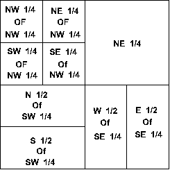
To the right is one section from the township T1S-R2E above . Within each section, land may be referred to as half sections, quarter sections, or quarter of a quarter section. (A one-sixteenth division is called a quarter of a quarter as in the NW1/4 of the NW1/4 in the example to the right.)

1/4 section = 160 acres
1/2 section = 320 acres
1   section = 640 acres
Section Divisions


Surname Search

A-B C-F G-H I-L M-O P-R S-T U-Z