
|
T 1 S, R 25 W Crystal
Township Railsback - near SE corner Sec 9 Deal & Watton aka Butler - SE corner, SW 1/4 NE 1/4 Sec 18 Wray aka Long Branch - NW corner Sec 28 |
T 1 S, R 24 W
|
T 1 S, R 23 W Aldine
Township abandoned Hellyer graves - SW 1/4, Sec 23 |
T 1 S, R 22 W Harrison
Township Sheley Cemetery - SE corner, NE 1/4 Sec 29 |
T 1 S, R 21 W
Almena
Township Fairview Cemetery - SE 1/4, Sec 4
|
|
T 2 S, R 25 W Rockwell
Township Norcatur Cemetery - Sec 30 City of Norcatur - in Decatur County |
T 2 S, R 24 W Garfield
Township |
T 2 S, R 23 W Center
Township Norton Cemetery - NW 1/4 Sec 35 City of Norton |
T 2 S, R 22 W Emmett
Township Bieber
aka Calvert Cemetery - |
T 2 S, R 21 W equally divided between Almena and Grant Townships Farmingdale Cemetery SE corner Sec 1 City of Almena |
|
T 3 S, R 25 W Clayton
Township Clayton Cemetery is in Decatur County, Sec 25, T 3 S, R 25 W |
T 3 S, R 24 W Leoti Township Oronoque Cemetery - NE 1/4 NW 1/4 Sec 15 City of Oronoque
|
T 3 S, R 23 W Orange
Township no cemeteries identified |
T 3 S, R 22 W Belle Plaine Township no cemeteries identified |
T 3 S, R 21 W Grant
Township Zellmer Cemetery - NW corner, SW 1/4 Sec 1 Mt. Olive Cemetery - SE corner, SE 1/4 Sec 15 |
|
T 4 S, R 25 W Noble
Township City of Clayton Gettis aka Gettys
1880
Cemetery
- |
T 4 S, R 24 W Highland
Township Prairie Gem Cemetery - NE corner Sec 13 |
T 4 S, R 23 W belongs to Orange, Modell and Solomon Townships. Mt. Pleasant United Brethren in Christ Church Cemetery - SE corner Sec 33 - no longer exists |
T 4 S, R 22 W Sand Creek Township no cemeteries identified |
T 4 S, R 21 W Lincoln
Township no cemeteries identified |
|
T 5 S, R 25 W Almelo
Township St. Joseph Cemetery - near SE corner Sec 22 City of New Almelo |
T 5 S, R 24 W Lenora
Township Lenora East aka Hendricks - SE corner NW 1/4 Sec 23 Lenora South - NE corner NE 1/4 Sec 27 City of Lenora |
T 5 S, R 23 W Modell
Township Modell Cemetery - NE corner Sec 14 |
T 5 S, R 22 W Solomon
Township abandoned Button grave - S 1/2 Sec 11 on private property Edmond Cemetery -
NW corner, NE 1/4 Sec 8 City of Edmond |
T 5 S, R 21 W West Union Township Calvary aka St. Mary's Cemetery - NW 1/4 NW 1/4 Sec 6 Densmore - NW 1/4 NW 1/4 Sec 6 City of Densmore West Union aka Archer Cemetery - NE 1/4 Sec 9 |
Cemeteries we have seen referenced in obituaries or newspaper articles, which either are (1) an alternate name for an existing cemetery, or (2) have ceased to exist, or (3) were referred to in error :
Birkville - probably the same as Mt. Olive Cemetery
Brighton
Hayes - probably the same as Mt. Olive Cemetery. The land was owned by
Marion Hays.
Patterson's - perhaps one of the Lenora cemeteries?
Spring Green - in Furnas County, Nebraska.
If you have any information on these cemeteries, please let me know. Ardie
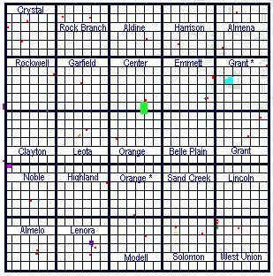
* Note: Township lines on the map above are drawn "on the squares", and may not reflect exactly the civil township boundaries.
Disclaimer: This information is compiled from many different maps and sources plus information provided by individuals. It may contain errors, which I will gladly corrected if documentation can be provided.
Last updated 22 February 2005