|


 Arlington,
Kansas
Arlington,
Kansas 
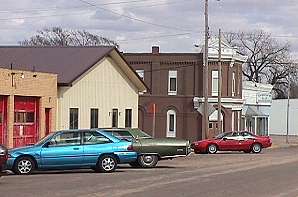
| Description | Arlington is located in Reno,
[RN], county. A branch of the gentle Ninnescah River runs along the
east side of town. Highway K-61 and the Southern Pacific tracks run
side-by-side through town, connecting Hutchinson and Pratt. The ruins of the old school on Howard Street show fine craftsmanship. |
|
|---|---|---|
| History | The site of Arlington was first settled about 1877 and the heights overlooking the Ninnescah valley were named for Arlington, Massachusetts. A nondenominational church was soon built, and a Presbyterian church organized in 1878. A Methodist church was formed in 1880. The city was chartered in 1887. | |
| Schools | USD 310 Fairfield (316) 596-2152 FAX:
(316) 596-2835 16115 S Langdon Road / Langdon, KS 67583-9307 |
|
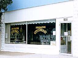
| Library | City Library (316) 538-2471 | |
| Churches | United Methodist Church (316) 538-3353 /
117 S. Lincoln Presbyterian Church (316) 538-2353 / 320 W. Main |
| Dining |
|
||||
|---|---|---|---|---|---|
| Shopping | Arlington General Store (316) 538-2424 / 107 W. Main | ||||
| Banking | Citizen's State Bank (316) 538-2266 / 116 S. Lincoln | ||||
| Lodging | Motel 61 (316) 538-2033 / Hwy 14 & Hwy 61 | ||||
| City Government |
 Emergency
- 911 Emergency
- 911City Hall (316) 538-2818
City Library (316) 538-2471
|
06/09/24