LANDOWNERS� DIRECTORY
SEDGWICK COUNTY, KANSAS
AS COMPILED FROM THE COUNTY ASSESSORS� RECORDS
Copyright 1915, by Rand McNally & Co.
The present system of surveying and describing lands, called the rectangular system, was adopted by the Government May 7, 1875. All distances are measured from two sets of Principal Lines, intersecting at right angles. One set, the Principal Meridians, run north and south. The other, called Base Lines, run east and west. At intervals of every six miles east and west of the Principal meridian and running parallel (i.e., north and south) with it, are established the Range Lines. The areas between these lines are numbered consecutively, Range 1 east, Range 2 east, or Range 1 west, Range 2 west, etc. At intervals of six miles north and south, the Base Line is also paralleled by lines running east and west. The area between these lines are knows as Township 1 north, Township 2 north, Township 1 south, Township 2 south, etc. The area of land enclosed by the intersection of the Township and Range Lines is six miles square and contains 36 square miles. This area is knows as a Congressional Township. The 36 squares in a Congressional Township are numbered from 1 to 36 and are called sections. A section is 1 mile square and contains, if properly laid out, 640 acres of land � a number easily divisible. Sections are most commonly subdivided into quarters by two lines intersecting each other at right angles in the center of the section. Other convenient subdivisions are also employed.
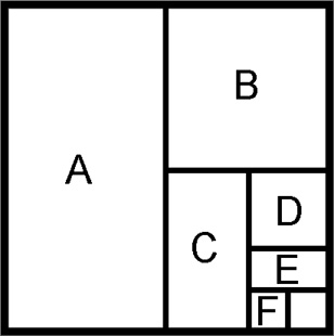
The descriptions in the Directory, such as NE4 or NW4, SE4 or SW4, refer to the northeast quarter, the northwest quarter, the southeast quarter, or the southwest quarter respectively of the section stated. In a combination of symbols the first always expresses a fraction of the second. Thus a description E2 NW4 would be the east half of the northwest quarter of a section. The symbol SE4 NW4 would be the southeast quarter of the northwest quarter, and the acreage of such a description would be 40 acres; while the acreage of the E2 NW4 would be 80 acres. The figure below illustrates a few subdivisions with descriptions and acreage:
Section

A � W2 ����� 320 acres
B � NE4 ����.. 160 acres
C � W2 SE4 ��� 80 acres
D � NE4 SE4 ��.. 40 acres
E � N2 SE4 SE4 �. 20 acres
F � SW4 SE4 SE4 .. 10 acres
For use on the Sedgwick County KSGenWeb page, the Directory has
been presented as it was in the original publication � in order by section
within each township. Additionally a second listing, alphabetical by landowner,
has been done to aid in searching. Please note that there are frequent spelling
errors in the original publication. These have been left as they were first
published.
1915 Sedgwick County Landowners, alphabetized by township - A through M
1915 Sedgwick County Landowners, alphabetized by township - N through Z
1915 Sedgwick County Landowners, alphabetized by landowner
Contributed to Sedgwick County KSGenWeb by Bill Pennington (billpenn@swbell.net)
and Paula Dunagan (pdun@swbell.net).
This page created for Sedgwick County KSGenWeb by John Schunk.
Not to be reproduced or redistributed without permission.