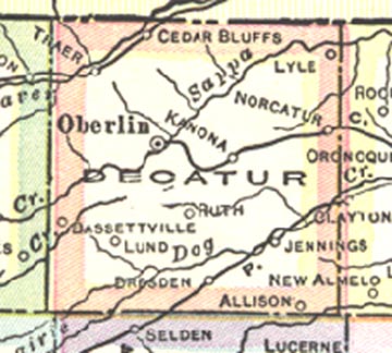
1921 Decatur County Kansas
taken from
the Official Paved Road and Commercial Survey
of the United States.
Copyrighted by the National Map Company
Geographers-Engravers-Publishers
1921
Map owned by Phil and Sharleen Wurm
1921
|
|
|
Surname Index of Landowners Alphabetical surname index of Landowners from all 25 townships. |
|
Township Plats Scanned pictures of each of the 25 townships. |
|
Index to Portraits This section is an index to the portraits of individuals, families and residents included in the atlas. |
|
Patron's Directory This section includes names, post office addresses, in some cases where they were born, and what year they became residents of the county. |
KSGenWeb logo was designed and is copyrighted by Tom & Carolyn Ward for the limited use of the KSGenWeb Project. Permission is granted for use only on an official KSGenWeb page. USGenWeb logo was designed by Linda Cole.