

Jackson County
KSGenWeb

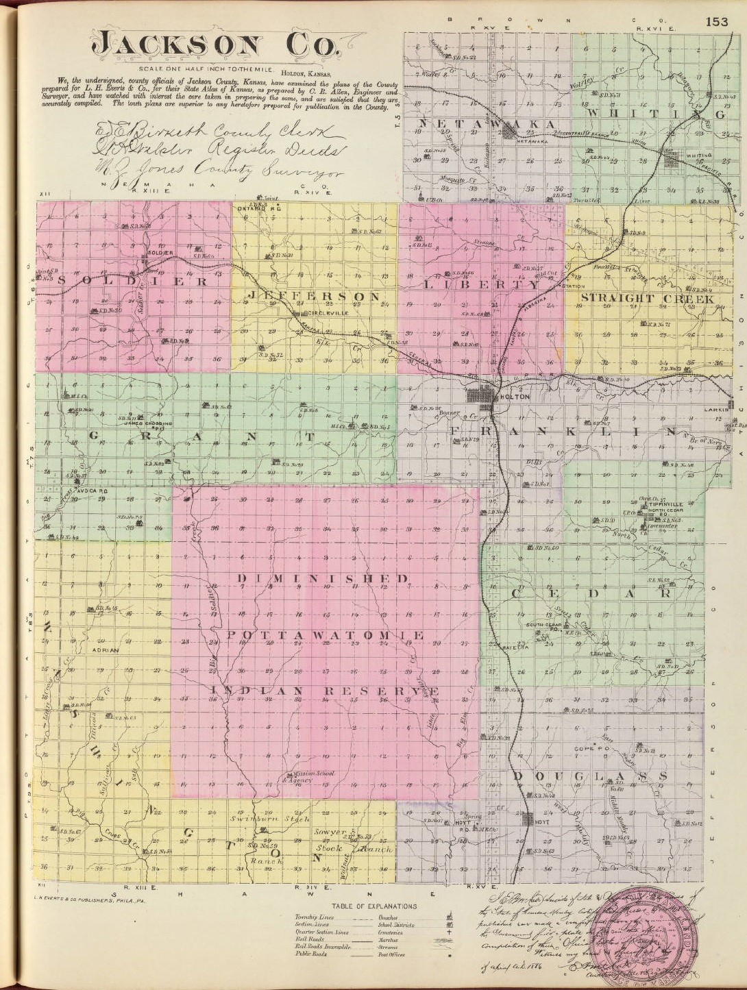
1887 Jackson County
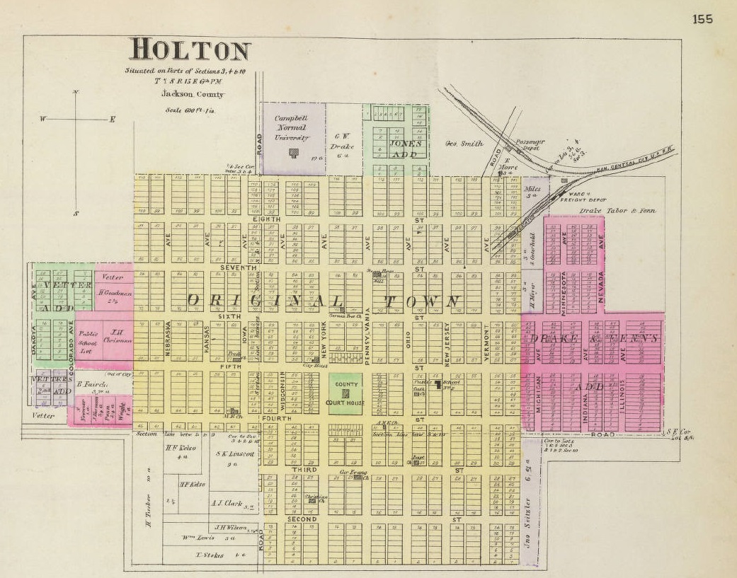
1887 Holton
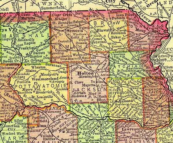
1895 Rand McNally Atlas
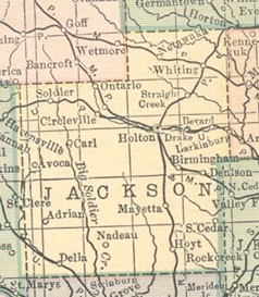
1914 Atlas
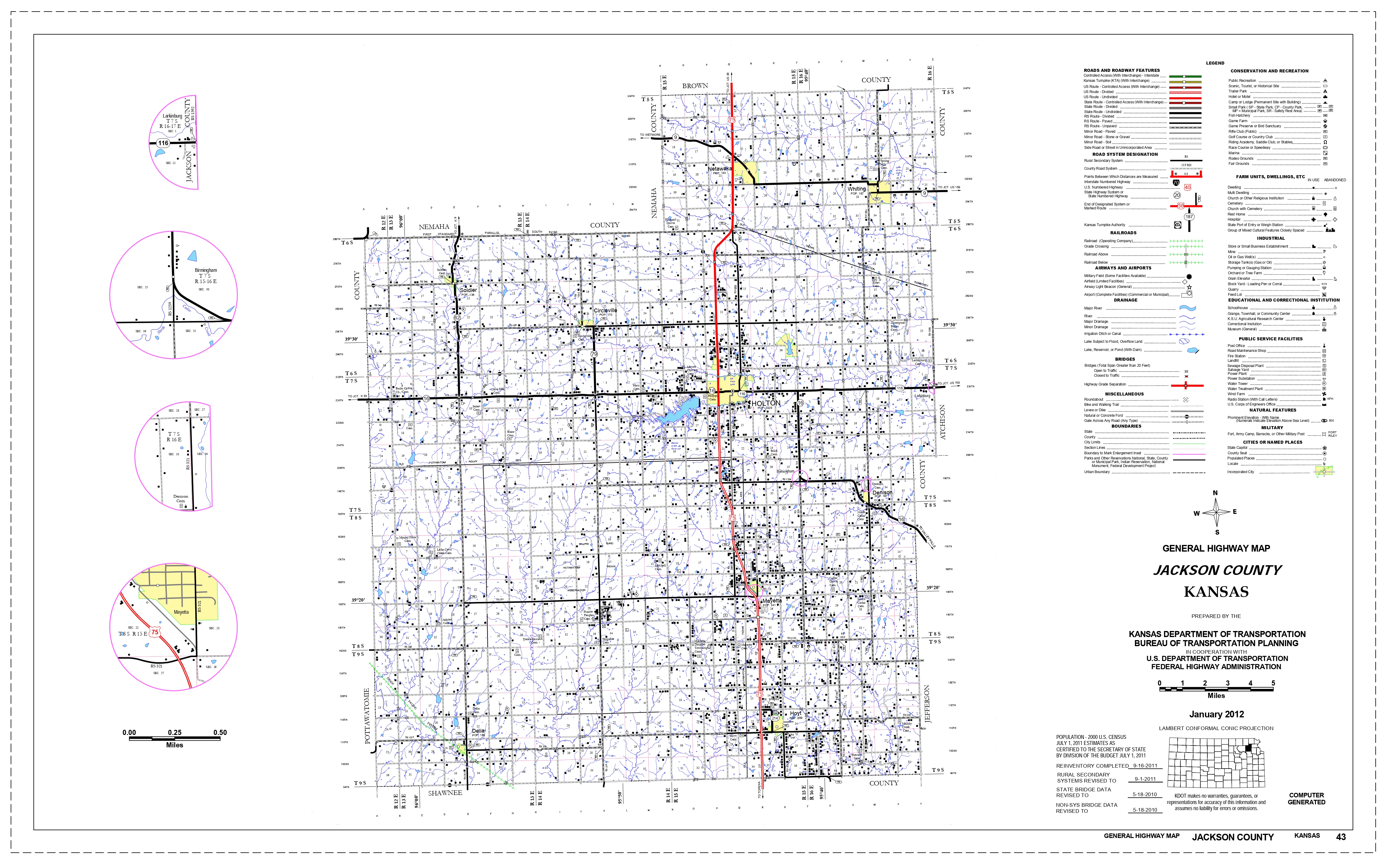
2012 Kansas Dept. of Transportation
Birmingham, a hamlet of Jackson county, is located on the Missouri Pacific R. R. 4 miles southeast of Holton, the county seat. It has a general store, a money order postoffice, telegraph and express offices, and a population in 1910 of 50. Extracted 2002 by Carolyn Ward from Kansas: A Cyclopedia of State History, volume I, page 187.
Circleville, a village of Jackson county, is located 8 miles northwest of Holton, the county seat, on the Union Pacific and Missouri Pacific railroads. It has banking facilities, telegraph and express offices and a money order postoffice with two rural mail routes. All the general lines of business are represented. The population in 1910 was 325. The town was founded by Maj. Thomas J. Anderson in 1863, and shortly after the survey Rufus Oursler erected a store and put up a combination grist and sawmill. In 1865-66 the Methodist Episcopal church erected a $10,000 seminary which was abandoned later for the reason that the church became interested in Baker University at Baldwin. For many years the building was used for school purposes. At the time the town was founded the people had to go to Jefferson for their mail, but later a postoffice was established at Holton. Extracted 2002 by Carolyn Ward from Kansas: A Cyclopedia of State History, volume I, page 350.
Delia, a little town of Jackson county, is located in the southwest corner of the county on the Union Pacific R. R. 20 miles southwest of Holton, the county seat. It has banking facilities, a money order postoffice with one rural route, telegraph and express offices, and the principal lines of business activity are represented. The population in 1910 was 100. Extracted 2002 by Carolyn Ward from Kansas: A Cyclopedia of State History, volume I, page 506.
Denison, one of the thriving towns in Jackson county, is located on the Missouri Pacific R. R. in Cedar township, 10 miles southeast of Holton, the county seat. Among the public improvements is a $2,000 electric light plant and a $5,500 school building. There are several well stocked stores, banking facilities, express and telegraph offices, and a postoffice with one rural route. The population in 1910 was 325. Denison is the successor of the old town of Tippinville, founded in 1858 by Welwood Tippin. This was a thrifty little town having a dozen business establishments, including one of the first cheese factories in Kansas. In 1887 when the railroad came through it missed Tippinville, going a mile south. The little town was picked up and moved bodily to the railroad. Most of the buildings moved at that time are still in existence. Extracted 2002 by Carolyn Ward from Kansas: A Cyclopedia of State History, volume I, pages 507-508.
Holton, the county seat of Jackson county, is located on a slight eminence to
the northeast of the central part of the county. It is one of the substantial
towns of northeastern Kansas having local manufacturing establishments and other
institutions which insure a good income to the town. There is a large brick
yard, soda and mineral water factories, cigar factory, planing mill, patent
medicine factory, 4 banks, 3 grain elevators, telegraph and express offices and
an international money order postoffice with six rural routes. The educational
facilities of Holton are exceptionally good for a town of its size. Besides good
graded and high schools there is a higher institution of learning known as
Campbell College, which has 4 good buildings and 8 departments. The population
of Holton in 1910 was 2,842.
Holton was founded in 1856 by a colony of
free-state people from Milwaukee, Wis. The party left Milwaukee in May of that
year with 6 wagons drawn by cattle. The expedition was financed by the Hon. E.
D. Holton, for whom the town was afterward named. The members of the company
included J. B. Coffin and family, Edmund G. Ross and family, J. B. Hutts and
family, the Lathrop family, six unmarried men and eight other persons, making a
total of 34 persons. At Janesville, Wis., they were joined by Andrew Smith's
family of five, Mr. Lyme's family of five, and another Ross family consisting of
five persons. When they reached Missouri they were robbed and warned to turn
back. They altered their course and went to Nebraska City, the rendezvous of
free-state men, where they met James H. Lane with 200 men who joined them taking
the Lane road to Kansas. The train now included 82 wagons. The party received
additions by Capt. Shombre of Indiana with 17 men, Doc Weed of Leavenworth with
20 men, Col. Harvey of Illinois with 60 men, and Capt. Stonewall with 75 men.
The second day out they met S. C. Pomeroy with a small party. The next day they
met John Brown with a few men who had come to inform Lane that a price had been
set upon his head, and to urge him not to go to Topeka, which advice was not
heeded and they continued on their way. When they came to Elk creek they cut
timber and built a bridge upon which to cross, and located where the Holton
central high school now stands. The town site was surveyed and a log cabin 20
feet square was built in such a manner that it could be used for defense and was
called "Jim Lane's Fort." The depredations of the Kickapoo rangers in the fall
caused the fort to be abandoned for a short time. A new company was organized in
Dec., 1856, and a survey made.
In 1857 several buildings were erected,
one being the Holton House by T. G. Walters, and another the Banner Hotel by E.
M. Parks. A school house was built by contributions, Squires & Stafford put in a
small stock of goods, and J. W. Gordon & Bro. started a general store. The next
year Holton was made the county seat. The first child was born to Mr. and Mrs.
Thomas G. Walters and named Holton Walters. He was presented with a town lot.
Factional differences were closely drawn in early times, the free-state men
and Republicans doing business on the north side of the public square and the
pro-slavery men and Democrats on the south side. There were two flag poles, one
Republican and the other Democratic. Their differences often came to blows and
sometimes to shots, Maj. Thomas J. Anderson being attacked at a convention at
one time and injured by a blow on the head. He was also fired upon several
times.
The town was incorporated in 1859 by Maj. T. J. Anderson, who was
then probate judge. Dr. James Waters was the first mayor and George L. Hamm,
city clerk. It became a city of the third class in 1871, and some years later
was made a city of the second class.
Extracted 2002 by Carolyn Ward from Kansas: A Cyclopedia of State History,
volume I, pages 865-866.
Hoyt, a town of Jackson county, is located on the Chicago, Rock Island & Pacific R. R. in Douglas township, 14 miles south of Holton, the county seat, and about the same distance north of Topeka. It is an important hay market, and is noted for large shipments of live stock. It has banking facilities, a newspaper, all the general lines of business, telegraph and express offices, and a money order postoffice with two rural mail routes. The town was founded in 1886 by a company of Holton men, of which I. T. Price and A. D. Walker were members. The promoters made a free dinner and sale, but no lots were taken. Later W. B. McKeage laid out on his farm 20 lots, which he sold at $100 each. A street of frame buildings was built by the town company fronting the railroad. Joseph Burns built a store for general merchandise. About 1895 the new street, which is the present business section, was built up of stone and brick buildings by the citizens. The population in 1910 was 400. Extracted 2002 by Carolyn Ward from Kansas: A Cyclopedia of State History, volume I, page 878.
Larkinburg, a hamlet of Jackson county, is located on the Leavenworth, Kansas and Western branch of the Union Pacific R. R. 9 miles east of Holton, the county seat. It is in the midst of a prosperous farming community and does considerable shipping. There are two stores, telegraph and express offices and a money order postoffice. The population in 1910 was 129. The town took its name from M. E. Larkin, who owned the land south of the town site. It was laid out in 1880, although a postoffice by the name of Larkin had existed since 1873, with Henry Priddy as postmaster. Extracted 2002 by Carolyn Ward from Kansas: A Cyclopedia of State History, volume II, page106.
Mayetta, a village of Jackson county, is located on the Chicago, Rock Island & Pacific R. R. in Cedar township, about 8 miles south of Holton, the county seat. All the general lines of business are represented, including a bank, telegraph and express offices. Three rural mail routes emanate from the Mayetta postoffice. The population in 1910 was 350. The town was founded by Mrs. H. E. Lunger, who laid off the lots on Dec. 1, 1886, and sold 16 of them immediately. She gave the railroad company some 10 acres of land on condition that she be allowed to name the town. The name is a combination of Mary and Henrietta, which was the name of Mrs. Lunger's little daughter who died some time before. Extracted 2002 by Carolyn Ward from Kansas: A Cyclopedia of State History, volume II, page 249.
Netawaka, a village of Jackson county, is located on the Missouri Pacific R. R. in Netawaka township, 10 miles north of Holton, the county seat. All lines of business are represented. There are banking facilities, express and telegraph offices, and a money order postoffice with two rural mail routes. The population in 1910 was 339. The name means "Fair view" and is the only one in the county of Indian significance. The first settler on the town site was B. F. Baughn, who began the building of the Netawaka House. The town was laid out in 1866 and Edward W. Kenyon, the pioneer merchant, opened the first store in 1868. He was the first station agent and agent for the Kickapoo lands in charge of the Union Pacific R. R. He was also the first postmaster. A grist mill was built by A. J. Evans in 1881. Extracted 2002 by Carolyn Ward from Kansas: A Cyclopedia of State History, volume II, page 354.
Soldier, a village of Jackson county, is located on the Union Pacific R. R. in Soldier township, 12 miles northwest of Holton, the county seat. It has all the main lines of business represented, banking facilities, a newspaper (the Clipper), telegraph and express offices, and an international money order postoffice with three rural routes. In 1910 the population was 500. The town was laid out in 1877 by Paul Havens, president of the Kansas Central Town company. The original survey contained 16 acres. Three additions by Logan & Friend laid out in 1895, 1897 and 1900 respectively comprise the north part of town. The residence section has recently been enlarged by Johnson's addition. The first settler on the town site was F. M. Wilson in July, 1877. The postoffice was moved from the ranch of William Cline, the name changed from Smithland to Soldier, and Mr. Wilson was the first postmaster. L. H. Thompson was the first station agent. On July 10, 1883, a cyclone struck soldier about 10 p. m., instantly laying waste the whole town east of Main street. Some sixteen or eighteen buildings were destroyed and four lives lost. The people began to rebuild immediately. The town was incorporated in 1896 and an election held on May 4 of that year. The first officials were: J. T. Holston, mayor; J. W. Fleming, police judge; F. M. Denny, C. E. Friend, George Smith, Dr. S. S. Reed and A. L. Fryberger, councilmen, and F. M. Wilson, clerk. Extracted 2002 by Carolyn Ward from Kansas: A Cyclopedia of State History, volume II, pages 711-712.
Whiting
Copyright © 1996 - The USGenWeb® Project, KSGenWeb, Jackson County

This page was last updated
06/29/2026