

Cloud County
KSGenWeb

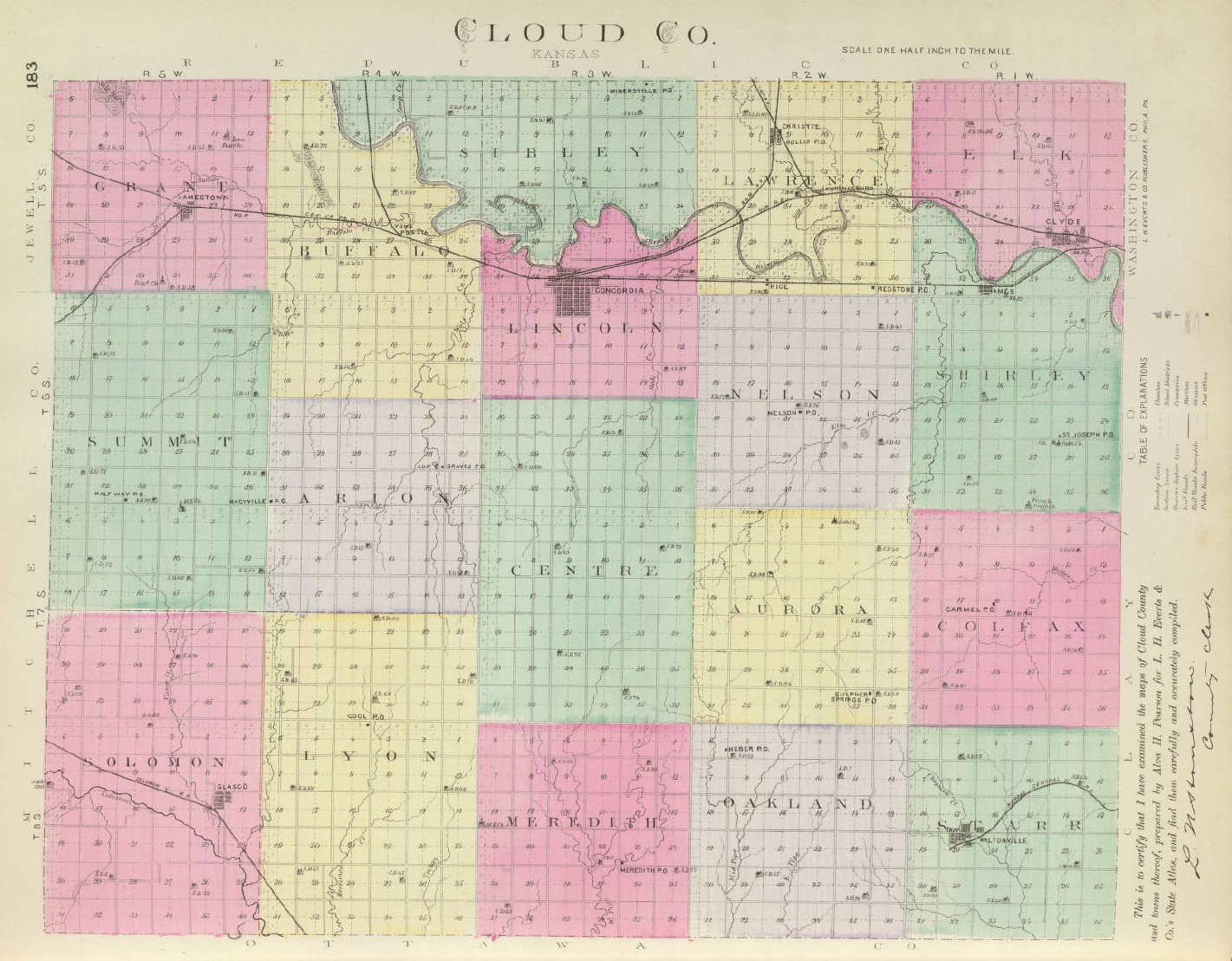
1887 Cloud County
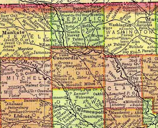
1895 Rand McNally Atlas
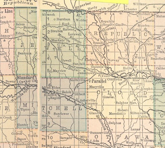
1914 Atlas
1915-1918 Stouffer's
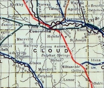
Railroad Map
Courtesy of Wikipedia
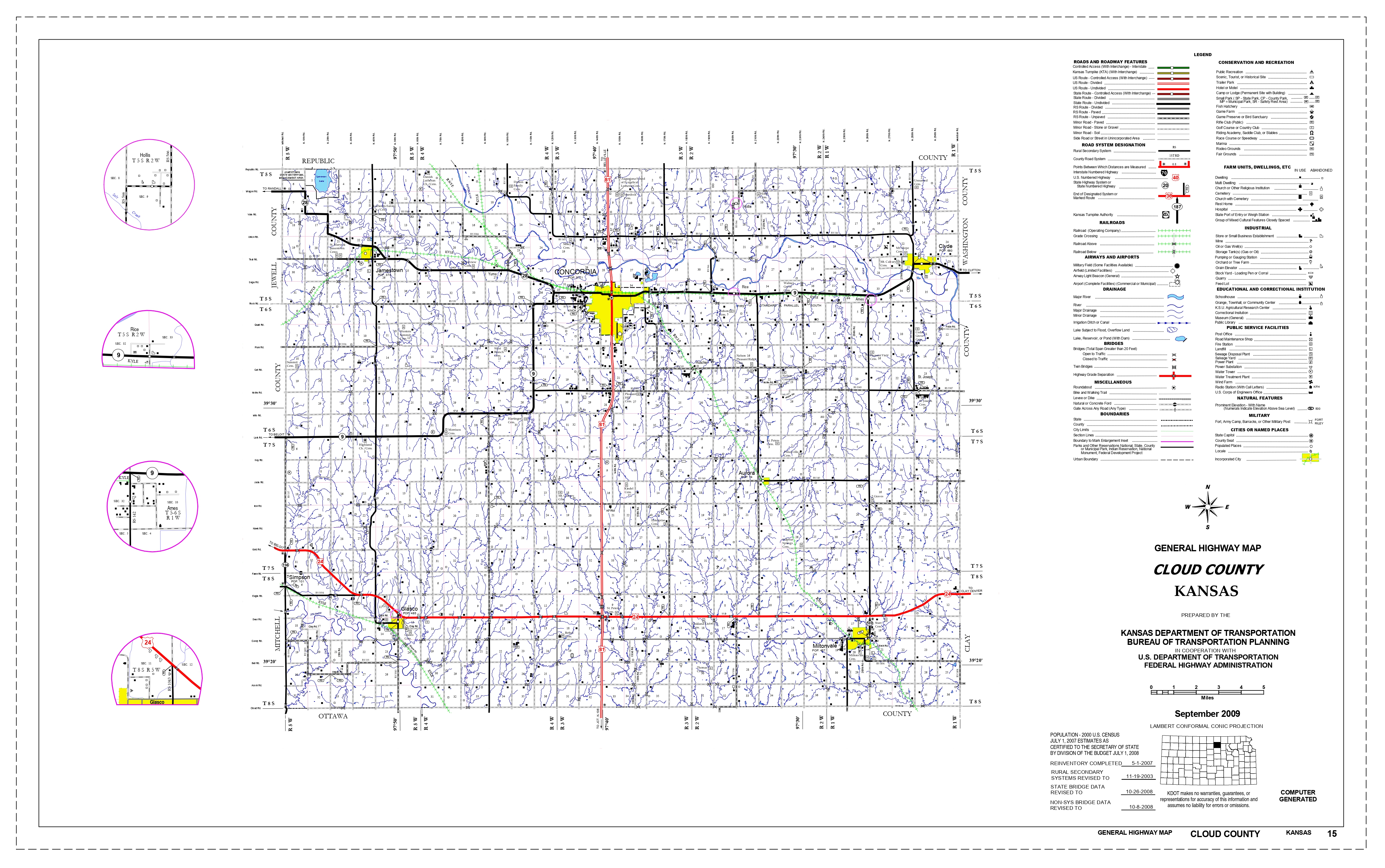
2009 Kansas Dept. of Transportation
Ames, a village of Shirley township, Cloud county, is a station on the Missouri Pacific R. R. 12 miles east of Concordia, the county seat. It has a money order postoffice with one rural delivery route, express and telegraph service, some good mercantile houses, and in 1910 reported a population of 120. Extracted 2002 by Carolyn Ward from Kansas: A Cyclopedia of State History, volume I, page 68.
Aurora, an incorporated town of Cloud county, is located in the township of the same name, on the Atchison, Topeka & Santa Fe R. R. that runs from Strong City to Superior, Neb., 12 miles southeast of Concordia, the county seat. It has a bank, a Catholic church, some good stores, a money order postoffice with two rural routes, telephone connection, telegraph and express offices, good schools, and in 1910 reported a population of 269. Extracted 2002 by Carolyn Ward from Kansas: A Cyclopedia of State History, volume I, page 120.
Clyde, an incorporated city of Cloud county, is located on the Republican river at the junction of the Chicago, Rock Island & Pacific, the Missouri Pacific and the Union Pacific railways, 15 miles east of Concordia, the county seat, and not far from the eastern boundary of the county. It is the oldest town in the county, the original site of 40 acres having been purchased from W. H. Page early in 1866 for $300 and soon afterward the town was laid out. Cowell & Davis had opened a store on the site before the town was platted. It was first named Shirley, which was also the original name of the county, but in a little while the name was changed to Clyde. For a time the growth was slow, but since the advent of the railroads it has been more steady and substantial, and in 1910 the population was 1,057. For a city of its size, Clyde is one of the most progressive and metropolitan in character in the state. It has well kept streets, an electric light plant, waterworks, a fire department, a sewer system, 2 banks, 2 theaters, 2 weekly newspapers (the Republican and the Herald), a commercial club, good hotels, a graded school system, several fine church edifices, a flour mill, a creamery, grain elevators, marble and granite works, and annually ships large quantities of grain, live stock, watermelons and alfalfa. Its international money order postoffice has five rural routes which supply a large district with daily mail, and the mercantile establishments of the city enjoy a large and profitable patronage. Telephone connection is maintained with the surrounding towns. Extracted 2002 by Carolyn Ward from Kansas: A Cyclopedia of State History, volume I, pages 375-376.
Concordia, the county seat and largest city of Cloud county, is beautifuly[sic] situated, a little north of the center of the county, on the Republican river and at the junction of the Atchison, Topeka & Santa Fe, the Missouri Pacific, the Union Pacific, and the Chicago, Burlington & Quincy railroads. When the county seat was located here by vote of the people in the fall of 1869, there was not a building of any kind on the site of the present city. That winter a one-story building 16 by 20 feet was erected for the use of the county commissioners, but only two meetings were held there, the board adjourning to Clyde, where better accommodations could he secured. Two town companies were organized soon after the election of 1869. The first, which was composed of G. W. Andrews, S. D. Houston, Sr., and J. M. Hagaman, owned what was known as the deeded part of the site, and the second, consisting of S. D. Houston, J. J., W. M. and Frank Burns, owned the Congressional site. Two surveys were made before the plat was finally adjusted to the satisfaction of all parties. In July, 1870, a United States land office was opened at Concordia and remained in operation there until consolidated with the Topeka office in Feb., 1889. There was a rush of applicants for lands, and the town grew accordingly. In Jan., 1871, Henry Buckingham removed the publication office of the Republican Valley Empire from Clyde to Concordia. On Aug. 6, 1872, Concordia was incorporated as a city of the second class, with R. E. Allen as the first mayor. The Concordia of the present day is one of the prettiest and busiest cities of its size in the state, as well as one of the most progressive in the matter of civic improvements. Its streets are well kept, and it has an electric lighting plant, a good sewer system, waterworks, a telephone exchange, a fire department, etc. The early settlers were mostly people from the eastern states, who understood the advantages resulting from good schools, and it is due to their influence that the city has three fine graded public school buildings. A Catholic school and convent are also located there. The commercial and industrial enterprises include 3 banks, 3 grain elevators, a flour mill, a creamery, brick and tile works, marble and granite works, a broom factory, ice and cold storage plant, cigar factories, planing mills, hotels, well stocked stores, etc. Concordia also has a Carnegie library of over 5,000 volumes, express and telegraph offices, and an international money order postoffice, from which six rural routes supply daily mail to the inhabitants of a rich and populous agricultural district. The population of the city in 1910 was 4,415, a gain of 1,014 during the preceding decade. Extracted 2002 by Carolyn Ward from Kansas: A Cyclopedia of State History, volume I, pages 396-397.
Glasco, an incorporated city of Cloud county, is located in Solomon township on the Solomon river and the Union Pacific R. R., about 20 miles southwest of Concordia, the county seat. It has 2 banks, an international money order postoffice with four rural routes, express and telegraph service, telephone connections, a weekly newspaper (the Sun), an opera house, graded and high schools, churches of the leading denominations, hotels, mercantile houses, etc. The population in 1910 was 720. Extracted 2002 by Carolyn Ward from Kansas: A Cyclopedia of State History, volume I, pages 750-751.
Hollis, a village of Cloud county, is situated in Lawrence township at the junction of the Chicago, Burlington & Quincy and the Union Pacific railroads, 8 miles northeast of Concordia, the county seat. It has a money order postoffice with one rural route, a telegraph office, a good local trade, does some shipping, and in 1910 reported a population of 50. Extracted 2002 by Carolyn Ward from Kansas: A Cyclopedia of State History, volume I, page 864.
Huscher, a post-village of Nelson township, Cloud county, is a station on the Atchison, Topeka & Santa Fe R. R. 6 miles southeast of Concordia, the county seat, with which it is connected by telephone. It has a local trade, does some shipping, and in 1910 had a population of 50. Extracted 2002 by Carolyn Ward from Kansas: A Cyclopedia of State History, volume I, page 891.
Jamestown, an incorporated city of the third class in Cloud county, is located at the junction of two branches of the Missouri Pacific R. R. and on Buffalo creek, 10 miles west of Coucordia, the county seat. It has a bank, a feed mill, stone quarries, 2 grain elevators, a weekly newspaper (the Kansas Optimist), telegraph and express offices and an internationl[sic] money order postoffice with four rural routes. There are about 50 business establishments. The population in 1910 was 462. The town was founded in 1878, and incorporated in 1883. Extracted 2002 by Carolyn Ward from Kansas: A Cyclopedia of State History, volume II, page 20.
Macyville, a hamlet in Cloud county, is located in Summit township 9 miles southwest of Concordia, the county seat, and about 11 miles northeast of Glasco, the postoffice from which its mail is distributed by rural route. The population in 1910 was 62. Extracted 2002 by Carolyn Ward from Kansas: A Cyclopedia of State History, volume II, page 210.
Miltonvale, a city of the third class in Cloud county, is located on the Atchison, Topeka & Santa Fe and the Union Pacific railroads, 21 miles southeast of Concordia, the county seat. It has 2 banks, a weekly newspaper (the Record), a hotel, all lines of mercantile enterprise, express and telegraph affices, and an international money order postoffice with four rural routes. The population in 1910 was 829. It is an important shipping point for grain, live stock and produce. Extracted 2002 by Carolyn Ward from Kansas: A Cyclopedia of State History, volume II, page 285.
Rice, a village in Cloud county, is located in Lawrence township on the Missouri Pacific R. R., 6 miles east of Concordia, the county seat. It has a money order postoffice with one rural route, some local trade, and the population in 1910 was 89. Extracted 2002 by Carolyn Ward from Kansas: A Cyclopedia of State History, volume II, page 579.
Sibley, a hamlet of Douglas county is located on the Atchison, Topeka & Santa Fe R. R. 7 miles south of Lawrence. It has a postoffice and express facilities, and in 1910 had a population of 25. The railroad name is Sibleyville. Extracted 2002 by Carolyn Ward from Kansas: A Cyclopedia of State History, volume II, page 694.
St. Joseph, a village in Cloud county, is located 15 miles southeast of Concordia, the county seat, and 8 miles south of Clyde, the postoffice from which it receives mail. The population in 1910 was 126. Extracted 2002 by Carolyn Ward from Kansas: A Cyclopedia of State History, volume II, page 631.
Yuma, a hamlet in Cloud county, is located on the Missouri Pacific R. R., 5 miles west of Concordia, the county seat and the postoffice from which it receives mail. Extracted 2002 by Carolyn Ward from Kansas: A Cyclopedia of State History, volume II, page 954.
Copyright © 1996 - The USGenWeb® Project, KSGenWeb, Cloud County

This page was last updated
07/24/2026