COMANCHE COUNTY KSGENWEB 2008: HISTORY & GENEALOGY

HOME     Bibliography     Biography     Cemeteries     Churches    Cities & Towns     Clubs     Contributors     Diamond Jubilee     Events     FAQ     Genealogy     Guest Book     History     Links     Maps     Military     News Articles     Newspapers     Opry     Photos     Poetry     Records     Satellite Images     Schools


William G. Deubler


The Western Star, February 4, 1949.

Pioneer Citizen Buried Last Saturday

Had Been a Resident of Comanche County Since 1884

Funeral services for Wm. Deubler, one of Comanche county's earliest settlers, were held in the Christian church in this city last Saturday afternoon at 2:30 p.m. and were in charge of Rev. Donald A. Kessler, pastor of the Methodist church in this city. Mrs. George Brown and Mrs. Merle Haun sang "The Old Rugged Cross" and "Beyond the Sunset," accompanied on the piano by Mrs. Jessie Robertson.

Burial was beside Mr. Deubler's wife, who passed away January 3, 1935. The pallbearers were Roy Lytle, Gloyd Hadley, Jack Ballar, L. B. Sailor, Earl Martin and Jim Copple.

Obituary

William G. Deubler, son of Mr. and Mrs. Gottlieb F. Deubler, was born June 7, 1864, in Warsaw, Ill., and departed this life at his home in Coldwater, Kans., January 27, 1949, at the age of 84 years, 7 months and 20 days.

Mr. Deubler spent his early life near the place of his birth. He came to Kansas in 1884 at the age of 20 and homesteaded in the southeastern part of Comanche county, where he continued to reside until moving to Coldwater about 30 years ago.

In 1892 he was united in marriage in Nescatunga township, this county, with Miss Emma Tripp, and to this union one child was born.

Mr. Deubler is survived by his daughter, Mrs. Arthur Sanders of Coldwater; two sisters, Mrs. Rosa Kurz of Coldwater and Mrs. Clara Blakely of Scandia, Kans.; one brother, John Deubler, of Selling, Okla.; five grandsons, eight grandchildren and many friends.

He was preceded in death by his parents, four brothers, four sisters, three grandchildren and his wife.

Mr. Deubler was a quiet and law-abiding citizen and a kind husband and father who took pride in his farming and gardening. The sorrowing relatives have the sympathy of all.
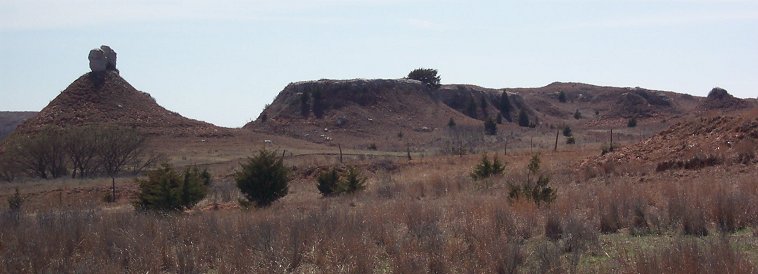
Deubler's Mound, aka Parker's Mound, Comanche County, Kansas.

'This picture shows the fence between the Merrill ranch pasture and the 'Deubler' pasture. The 'split rock' formation on the mound is a prominent landmark in the area. We call it Deubler's Mound or Parker's Mound.'

Photo taken by Phyllis Scherich, 30 March 2003.
Deubler's Mound, aka Parker's Mound, Comanche County, Kansas.
"This picture shows the fence between the Merrill ranch pasture and the "Deubler" pasture.
The "split rock" formation on the mound is a prominent landmark in the area."
Photo & comments by Phyllis Scherich.


The Western Star, June 2, 1922.

MEMORIES OF EARLY DAYS.

A few Reminiscences of Pioneer Life in Comanche-co.
by William G. Deubler

Thirty-five or more years ago, even Illinois, and especially that portion along the Mississippi River, was inclined to be a favorite harboring place for "fever and ague." It was partly for that reason, and with the hope that he could find a healthier climate, that, early in the year 1884 Wm. G. Deubler, who then lived near Warsaw, decided to come to Kansas. His father and a sister had already come west and had been residents of Wichita for about ten years. After visiting in Wichita for a few weeks, young William, in company with a friend, a Mr. Keyes, purchased a team and wagon and started out for Comanche-co., coming by way of Medicine Lodge and Sun City.

Their introduction to Comanche-co. was at Uncle Bobby Estill's ranch on Mule Creek. From there they came to Evansville, which was then the headquarters of the Comanche Pool, the biggest cattle company in this part of the state at that time. In a few days they had been "located" on good claims which included some of the best land along the Salt Fork, south of the old Evansville site, which was located on what is now the Arrington (formerly the Platt) ranch.

Mr. Deubler was not long in getting some improvements started on his claim. He hauled lumber from Kinsley, 75 miles away and built a substantial cabin on his claim. The cabin, he says, had at least one redeeming feature - a good shingle roof. The cabin was not very far from the creek and not long after it had been built which was in the early part of April, 1885, there came a very heavy rain and windstorm. It was one of the heaviest rains which had ever visited this county. The rain raised the creeks until they overflowed their banks and covered large areas of ground. Most of the settlers had nothing but dugouts, nearly all of which had dirt roofs, and the heavy downpour of rain soon rendered these roofs useless. In fact, many of the sod cabins were soon only a heap of mud. For that reason, Mr. Deubler's newly built was the refuge for a day or two a good many of his neighbors whose sod houses had melted under the downpour of rain. The water in Salt Fork raised until it had reached a depth of several feet in Mr. Deubler's house. Mr. Deubler says that he never saw so much water in Comanche-co. as he did that spring.

Among Mr. Deubler's early day experiences, he also relates this: One day he took his gun and went down in Fancy Canyon, a few miles south of where R. W. Scott now lives, in search of some game. He had not gone very far when he passed a big cave in the side of the canon, and as he did so he spied not far inside the cave a ferocious looking animal of the mountain lion or wild cat species. He could scarcely trust the gun he carried, so he looked the animal squarely in the eyes and gradually backed away until it was considered perfectly safe to run. But the next day he and his companion, Mr. Keyes, each with a trusty gun, went to the cave, and there they found the animal and they soon "had his bacon," as Mr. Deubler puts it.


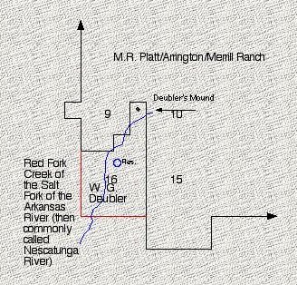
Map of the location of Deubler's Mound in Comanche County, Kansas.

Map and comments by Phyllis Scherich.
Location of Deubler's Mound in Comanche County, Kansas
Map courtesy of Phyllis Scherich.

"Deubler was located just south of the Platt/Arrington/Merrill Ranch. Here is a small diagram showing it. The home was where the blue circle is. This is still an interesting area. Much remains of the original homestead area including a windmill with a square tank (which was easier to form a square than a circle), multiple remains of small buildings, remains of a cattle pen, remains of a dugout with whitewashed walls still visible - probably used for storage, etc.

The land is now owned by the Beeley Trust."

-- Phyllis Scherich, 10 Dec 2005.


"The imperfect knowledge of the geography of the Plains region at that period resulted in confusion concerning the identity of certain streams. The Medicine Lodge Peace Treaty Council was actually held in the valley of the Medicine Lodge River, instead of in that of the Nescatunga as stated by Governor Taylor. The Medicine Lodge is a tributary of the Nescatunga, which is better known in Oklahoma as the Salt Fork of the Arkansas. The name Nescatunga is derived from the Osage Ne-skus-tonga, which means literally translated is "River Salt Big," or Big Salt River if rendered into proper English. The French trappers and traders of the eighteenth century Gallicized the Osage name without impairing its signification's by calling it the Grand Saline, aand as the Nescatunga, or Crand Saline, it was designated on maps of the Indian Territory down to about 1870. The more commonly accepted Salt Fork is believed to have had its origin in the usage of the freighters and cattle drovers who had occasion to ford it on the Chisholm Trail."

-- MEDICINE LODGE PEACE COUNCIL - A Graphic Description of Famous Peace Council By An Eye Witness, Gov. A. A. Taylor of Tenn., The Barber County Index, September 29, 1927.


Also see:

James W. Dappert: Reminiscences of Early Days in Comanche-co.
(Includes another mountain lion story)
The Western Star, January 15, 1926.

Obituary: Mary E. Deubler (Mrs. Wm. G. Deubler), The Western Star, December 31, 1920.


Thanks to Shirley Brier for finding, transcribing and contributing the above news article and obituary to this web site! Thanks to Phyllis Scherich for her comments, the photo and the map!

This website is being created by HTML Guy Jerry Ferrin with the able assistance of many Contributors. Your comments, suggestions and contributions of historical information and photographs to this site are welcome. Please sign the Guest Book. This page was last updated 10 Dec 2005.