Jonathan Farren of Amesbury, MA, & Newton, NH (circa 1697 - 5 May 1770), owned two different farms in his time. The first, of about 15 acres, was to the northwest end of Bear Hill in what was then the Second Parish of Amesbury, MA, and is now part of Merrimac, MA. His second farm, which he called his "Homestead Living" in his will, was located near Dugway Road in what is now Newton, NH.Arthur Ferrin and Loren Ferrin, pioneer settlers in Comanche County, KS, were 6th generation descendants of Captain Jonathan Farren, as follows: Arthur & Loren6, Rueben5, Zebulon4, Zebulon3, Zebulon2, Jonathan1.
George G. Gleason and I, Jerry Ferrin, have worked together for several years to identify the exact location of Jonathan Farren's farm. George grew up in Amesbury and still lives in the area. He has long been interested in identifying the exact locations of early land grants in the area, using historical records and lots of legwork in the field, to correlate the records to the area today.
The exact location of Jonathan Farren's farms is still unknown, though the areas where they were is known and will be seen in several ways on this webpage.
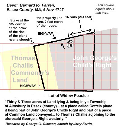 On 6 Nov 1727, Jonathan Farren bought John Barnard's farm, which was described in the deed as follows:
"...Thirty & Three acres of Land lying & being in ye Township of Almsbury in Essex (County) aforesaid att A place called Cottels plane it being part of John George's Childs Right and part of a piece of Common Land conveyed by the Commoner's Committee unto Thomas Challis adjoining to the aforesaid George's Right westerly and the whole land now Sold bounded as followeth: Southerly with a Lott of Joseph Peaslees alias Widow Peaslees with a Stake & heap of stones att the Southwesterly corner in Running Northwestwardly to a stake & heap of stones to a stake & heap of stones adjacent to a high Way Westwardly to a Stake & heap of stones att the Northwestwardly Corner att the brow of the rose of the plane near a Slough, Then Running Northeasterly to a stake & heap of stones as so running within Two foot Northward of the said Barnards dwelling House to a stake & heap of Stones att the line of said Peaslees Lott. So far in Distrance from ye Stake & heap of stones first mentioned as will allow to make up & compleat the aforesaid Thirty & Three Acres. To Have and to hold... together with all the buildings fences fruit trees as well as other trees Thereon Standing or being with all..." (Source: Essex County Deed Book #61, page 5, deed recorded 3 Feb 1731.)
Here's another description of Jonathan Farren's homestead from the Rockingham County Deed (V. 186, p. 301) of Aquilla Ferran to Thomas Colby where Colby paid 180 pounds lawful money of the Commonwealth of Massachusetts for...
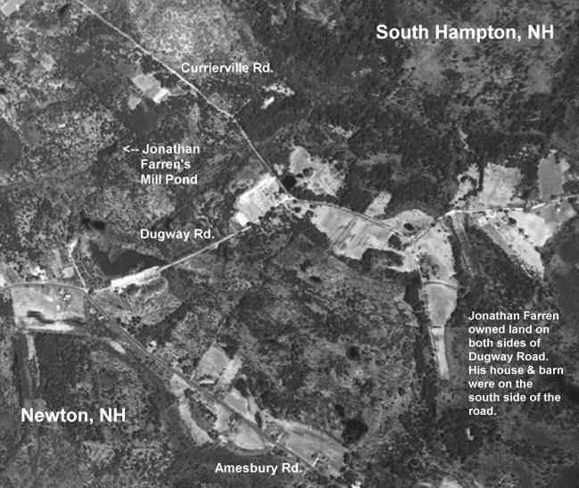
"...Thirty three acres of Land in Newton aforesaid with the house and Barn on the same being where I the said Farrin lately lived, which Land my honored Father Jonathan Farren bought of John Barnard by a deed dated November the first 1727, also about five acres of Land adjoining the above said Land, which my said Father bought of James George by a deed dated May 14, 1762 and bound agreeable to the above said deed Viz Westerly and Northerly on highways, and Easterly and Southerly on Land of his the said Colby and on Lands of Tuxbury. Also Six Acres of Land in Newton above said which my said Father Jonathan Farren bought of David Goodwin by a deed dated May the 14, 1763 and bound Southerly on land of his the said Colby, Easterly on a highway, Northerly and westerly on land of Currier -- Also a Pew in the Meeting house in Newton abovesaid on the lower floor being the first Pew on the left hand going in the ____(?) doors."
You can see the area where this land was located in the following aerial photograph. Note that land parcels can clearly seen in many cases. Which of them, though, were the ones which belonged to Jonathan Farren?
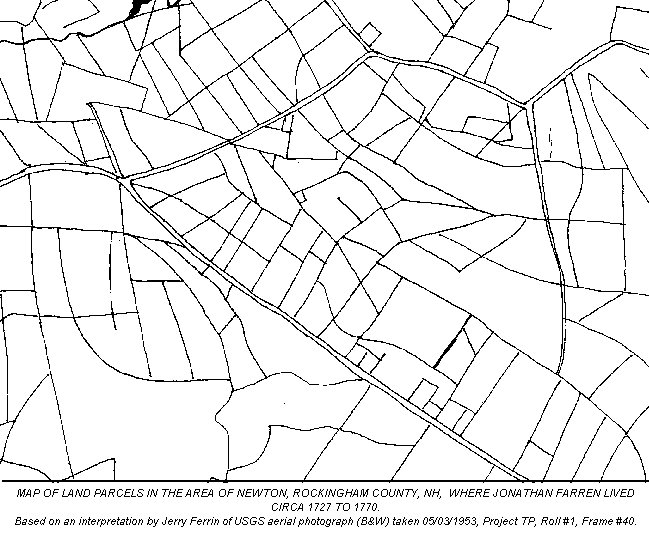
 The above map was created by tracing what appear to be land divisions in the 1953 aerial photograph of the area. It is certainly not completely accurate in depicting land parcels in the area, yet I believe it is generally accurate and does illustrate the complexity of the layout of the land parcels if nothing else.
Something to bear in mind as you attempt to locate the land is that the "highways" referenced in the deeds may be, as George says, highways in the sense that we think of roads today, byways or what we'd think of nowadays as paths through a pasture. Thus, any of the above lines on the map might represent an accessway to a piece of land which might have been described in contemporary deeds as "highways".
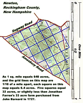
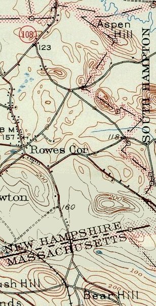
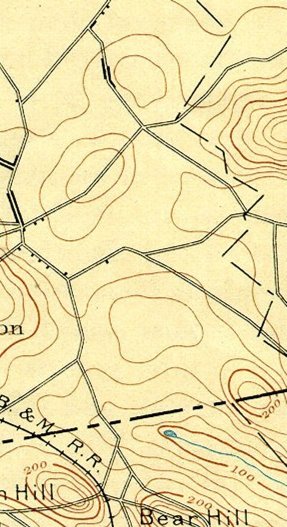
Three USGS maps showing the area of Jonathan Farren's two farms.
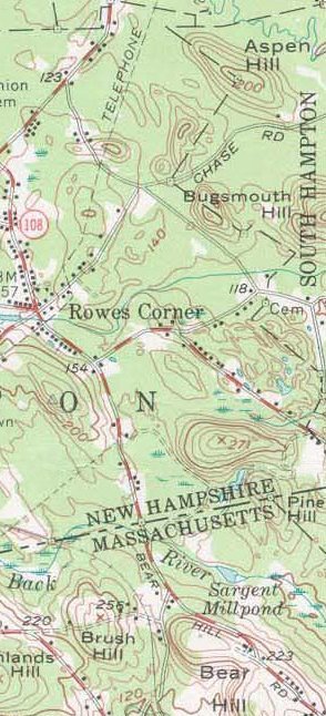
 Above left: 1956 USGS map of the boundary between Newton & South Hampton, New Hampshire.
Above right: 1935 USGS map of the same area.
Left: 1893 USGS map of the same area.
The Return of Weed's Lot,
The Children's Division,
Amesbury, Essex County, Massachusetts,
30 March 1719
"_________ 1st lot in number in that division of land called The Chil____ bounded as followeth: at ye Southeast corner with a white oak tree marked SC which is Samuel Colby's bound straight from there to a white oak tree on ye Northwest end of Bear Hill marked FH straight from there to a white stump near Jonathan Farren's house: straight from there to ye white oak tree marked SC first mentioned: abutting westerly on ye original right of Nathan Gould and south partly on a highway and partly on ye town common- _______d partly on ye original right of Geo. Martin.
"The Return of Weed's Lot" is the earliest known record of Jonathan Farren of Amesbury, MA, & Newton, NH. Prior to the discovery of this document by George G. Gleason in the Amesbury Town Records, the earliest known record of Jonathan Farren was on 10 December 1719, when he married Sarah Wells in Amesbury at a ceremony conducted by her grandfather, Rev. Thomas Wells.
So now we know that Jonathan Farren was living in a house on the "northern" half of Nathan Gould's lot in the Children's Division on 30 March 1719 a full nine months before he was married. At the time, this parcel of land belonged to Thomas & Elizabeth (Gould) Beadle; she inherited it from her father.
(Incidentally, note that one side of the Weed Lot abutted land originally granted to George Martin; this was the man whose widow, Susanna Martin of Amesbury, was hanged at Salem in 1692 after having been convicted of practicing witchcraft.)
The land where Jonathan lived in 1719 was the same parcel of land deeded to "our son Jonathan ffarren" on March 6th, 1726/7 by Thomas & Elizabeth Beadle with the odd provision that the gift could be revoked if either of them were ever in need. (Deed: Thomas Beatol to Jona. Farren, recorded 3 Feb 1731, Essex County, MA, Deed Book 59, page 107. LDS Family History library microfilm # 0866040)
This parcel of land was sold by Jonathan Farren to Charles Sargent on March 4th, 1762, and the deed was recorded on October 29th, 1765. (Essex County, MA, Deed Book 119, page 186. LDS Family History microfilm # 0866068)and is probably part of the Sargent Farm which is still in the same location today, though, due to shifting town boundaries, it is now part of Merrimac, MA.
On a map, look at the area between Bear Hill Rd. and Sargent's Pond to see roughly where this lot is located. If you use a topo. map, it's easier to locate the northwest corner of "Bear Hill" (which is actually a set of 3 hills) where Jonathan Farren's house was referenced in the "Return of Weed's Lot" in the Children's Division of Amesbury, MA" on 30 March 1730.
The Ferrin Family Newsletter # 9 includes a foldout map section in which modern topographical maps of the area are juxtposed w/an 1884 land parcel map of the area and a 1953 B&W aerial photo of the area. Many of the land parcels deliniated in the 1884 map can be seen clearly in the aerial photo.
To see this area on a US Geological Service map, find "Haverhill Quad, MA/NH, 7.5 minute series".
The 1884 map mentioned is from "The Old Maps of North-Eastern Essex County, Massachusetts, in 1884". A few of the landowner's names in this area are given on the map, which would be helpful to anyone attempting to trace land records to definitely establish the exact location of this land. The 1953 aerial photo can by ordered from USGS by calling 1-800-USA-MAPS. Order "USGS aerial photograph - black and white - taken 5-3-53, Project TP, Roll #1, Frame 40. As I recall, the cost of an 18"x18" print was about $22.00, and that included shipping in a tube.
You can also find a satellite image of this area at the TerraServer website. Sargent's Pond is visible at top right in the image and Bear Hill Rd. runs diagonally towards the upper left side of the image. The images are large & slow to load, but they're worth the wait.
This RootsWeb website is being created by
Jerry Ferrin with the able assistance of many Contributors. Your comments, suggestions and contributions of historical information and photographs to this site are welcome. Please sign the Guest Book.
Jerry Ferrin's descent from Captain Jonathan Farren, is as follows: Jerry Dean Ferrin9, Wendel Gene Ferrin 8, Ernest Leroy Ferrin7, Loren Ferrin6, Rueben Ferrin5, Zebulon Ferrin4, Zebulon Ferrin3, Zebulon Farren2, Jonathan Farren1.

Bibliography Biography Cemeteries Churches Cities & Towns Clubs Contributors Diamond Jubilee Events FAQ Genealogy