

Marshall County
KSGenWeb

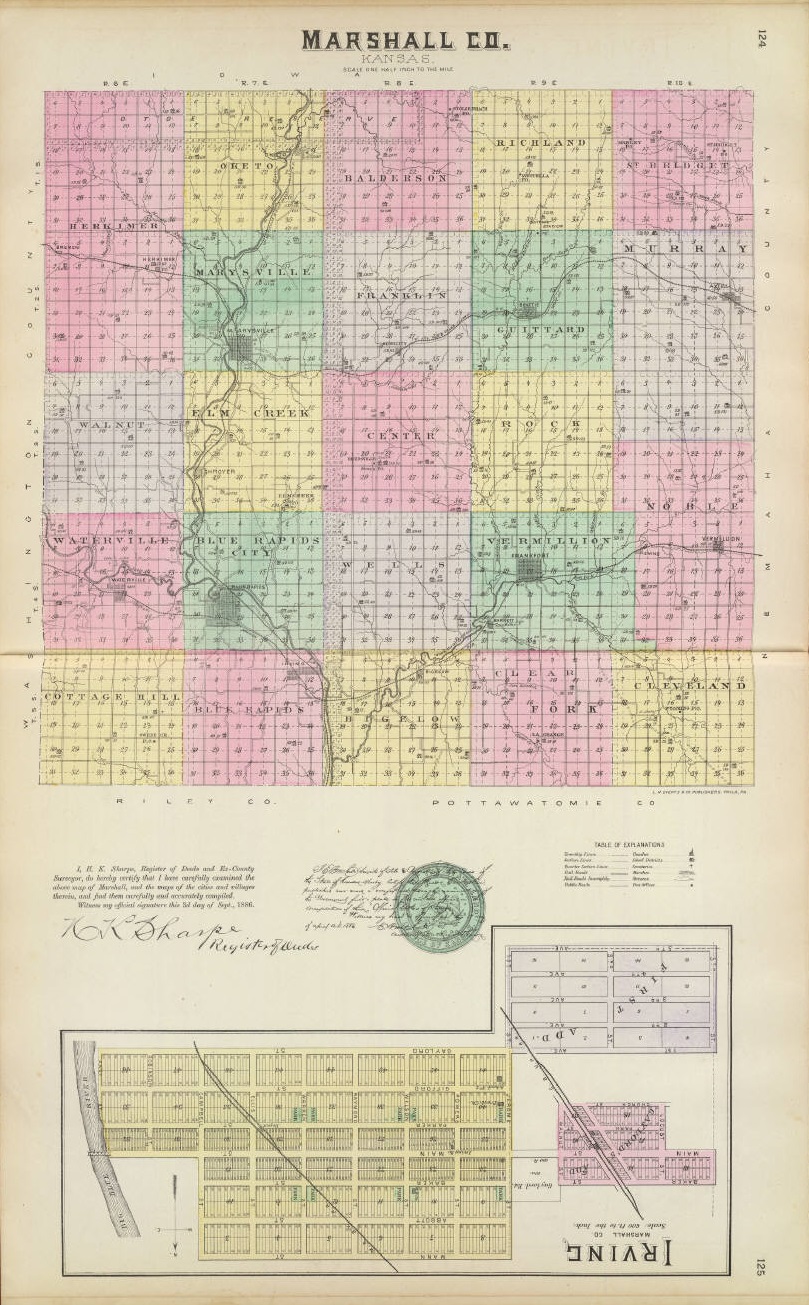
1887 Marshall County
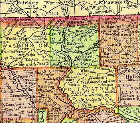
1895 Rand McNally Atlas
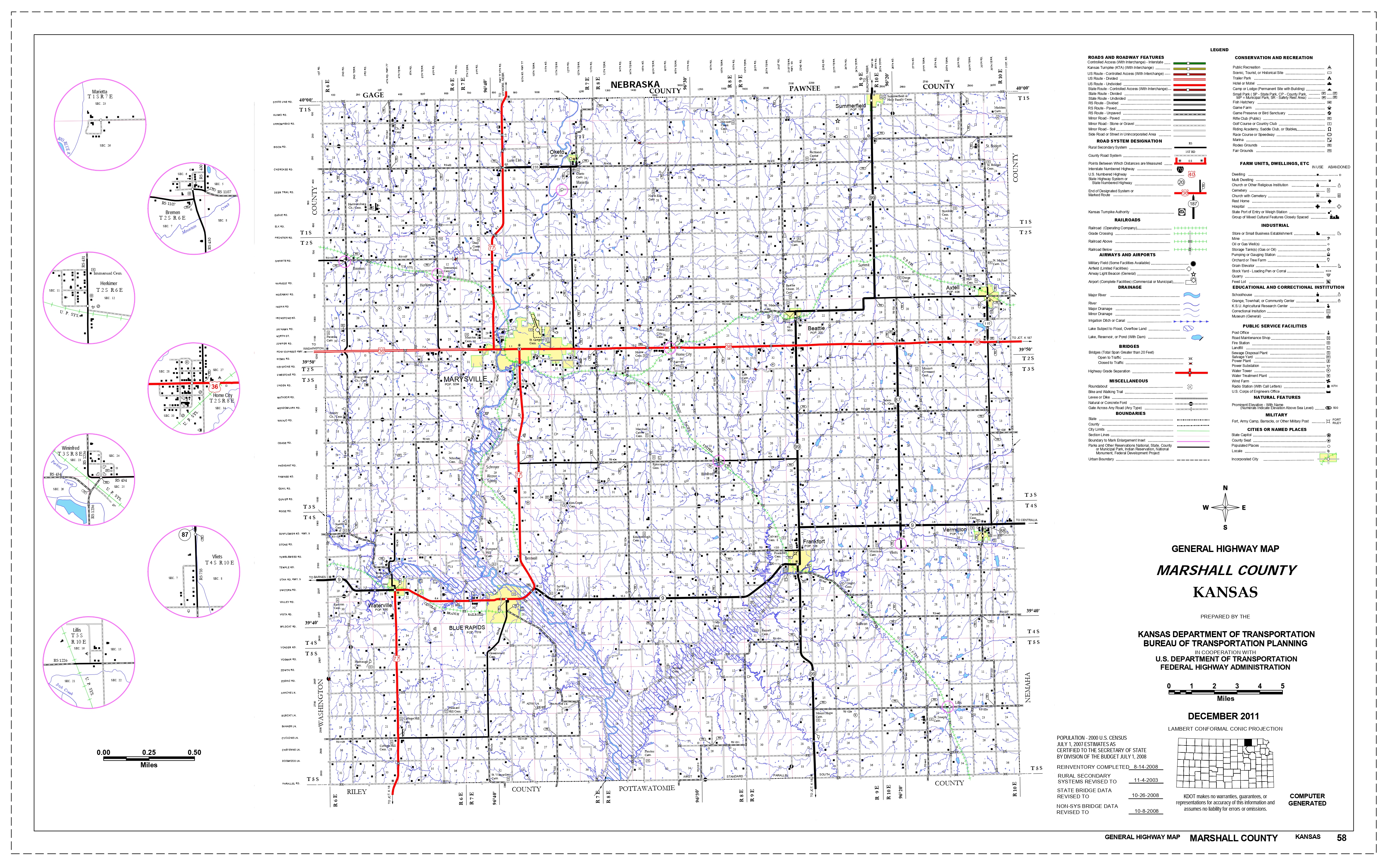
2011 Kansas Dept. of Transportation
Axtell, an incorporated town of Marshall county, is located in Murray township, 25 miles east of Marysville, the county seat, at the junction of the Missouri Pacific and the St. Joseph & Grand Island railroads. It has banking facilities, a weekly newspaper, a money order postoffice with three rural routes, telegraph and express offices, and had 748 inhabitants in 1910. The community was settled in the '60s and the town was laid out in 1872 by the St. Joseph Town company. The postoffice was established the same year. The first store was kept by a man known as "Shoestring" Dickinson. Extracted 2002 by Carolyn Ward from Kansas: A Cyclopedia of State History, volume I, page 120.
Beattie, a village of Marshall county, is located in Guittard township, 15 miles east of Marysville, the county seat, on a branch of the Vermillion river and on the St. Joseph & Grand Island R. R. It has banking facilities, a newspaper, telegraph and express offices, churches and schools, and a money order postoffice with two rural mail routes. The population in 1910 was 500. The neighborhood about Beattie was settled prior to 1865 by Hugh Hamilton, H. G. Smith, Eli Goldsberry, E. Cain, J. Trotten, G. Thorne, James Fitzgerald and P. Jones. The town was laid out in 1870 by the North Kansas Land and Town company of St. Joseph, Mo., on land owned by James Fitzgerald and John Watkins. The original town site consisted of 160 acres, and the town was named Beattie in honor of Hon. A. Beattie, then mayor of St. Joseph, Mo. The postoffice was established in 1871, and the first store was built by L. Brunswick in 1872. Extracted 2002 by Carolyn Ward from Kansas: A Cyclopedia of State History, volume I, page 163.
Bigelow, a village of Marshall county, is located on the Missouri Pacific R. R., 20 miles southeast of Marysville and 6 miles east of Irving. It has banking facilities, express and telegraph offices and a postoffice with one rural route. It was laid out in 1881, the immediate occasion for making it a shipping point being the limestone quarries recently opened in the vicinity. The population in 1910 was 200. Extracted 2002 by Carolyn Ward from Kansas: A Cyclopedia of State History, volume I, page 180.
Blue Rapids, one of the principal towns of Marshall county, is located
12 miles south of Marysville, the county seat, a short distance below the
junction of the Big and Little Blue rivers. It is second in size among the towns
of the county and is an important manufacturing point on account of the
excellent water power obtainable. It has a glove and mitten factory, cigar
factory, electric plaster mills, banks, hotels and city waterworks. The Union
Pacific R. R. running north and south and the Missouri Pacific east and west
form good shipping facilities. According to the census of 1910 Blue Rapids had
1,756 inhabitants.
The first attempt to establish a town on the site of
Blue Rapids was in 1857, when a town was laid out by James Waller, who lived on
Elm creek, Henry Poor and M. L. Duncan. Walter died, Poor shot and killed an
officer of the army, then encamped at Marysville and was obliged to leave the
country. The town was abandoned by Duncan and no other attempt was made to
utilize the water power until 1870 when a colony from Genesee county, N. Y.,
came in. A location committee consisting of Rev. C. F. Mussey, H. J. Bovee and
J. B. Brown came in advance and located the site for the proposed town. About
fifty families followed, among them were, S. H. Parmalee, T. Holbrook, R.
Robertson, M. T. Coe, D. Fairbanks, S. Smith, J. T. Smith, H. S. Hurlbert, J. B.
Waynant, C. J. Brown, G. R. Brown, T. F. Hall, J. B. Brown, C. E. Olmstead, J.
L. Freeland, J. V. Coon, R. S. Craft, John McPherson, J. F. Ball, Y. Douglas, H.
A. Parmalee, J. Yurann, V. R. North, H. Woodward, E. L. Stone, J. S. Fisher, C.
F. Roedel and C. F. Mussey.
They bought from R. S. Craft and others a
town site of 287 acres, embracing the water power privileges, for $15,000, and
secured 8,000 acres of farming lands. Among the improvements made the next year
was a dam of stone, at the point where the rapids begins, and a wrought iron
bridge. The first business enterprises were, two general stores opened by H. A.
Parmalee and Yates Douglas and a drug store by A. W. Stevens. W. H. Goodwin was
the first lawyer and Dr. R. A. Wells the first physician. The manufacture of
brick was begun in 1872 by Mr. Seip.
Blue Rapids was incorporated as a
city of the third class on March 20, 1972. The first election was held in the
town house, which was called "Colonial Hall," in April. C. E. Olmstead was the
first mayor.
Blue Rapids is one of the beauty spots of the state. It is
laid out on a gentle slope running down to the river, which is a beautiful sheet
of water. The current of the river strikes an abrupt rock about 40 feet high on
the right bank and turning to the left ripples over a solid rock bottom, forming
the rapids. It is in the midst of a rich farming district.
Extracted 2002 by Carolyn Ward from Kansas: A Cyclopedia of State History,
volume I, pages 197-198.
Bremen, a village of Marshall county, is located in Logau township 9 miles northwest of Marysville, the county seat, on the St. Joseph & Grand Island R. R. It has banking facilities, telegraph and express offices and a postoffice with two rural mail routes. The population in 1911 was 200. Extracted 2002 by Carolyn Ward from Kansas: A Cyclopedia of State History, volume I, page 233.
Frankfort, the third largest town in Marshall county, is located on
the Vermillion river and the Missouri Pacific R. R., 18 miles southeast of
Marysville, the county seat. It is on the route of the Union Pacific branch
which is building from Onaga. All the principal lines of business are
represented. The main commodities shipped are grain and produce. There are good
schools and churches, weekly and daily newspapers, express and telegraph
offices, and six rural delivery routes go out from the Frankfort postoffice.
The neighborhood of which Frankfort became the trading point was settled in
1855-56 by freestate men from Ohio and Pittsburgh, Pa.
After various
attempts to make a town, Frankfort was laid out in 1867 by a town company of
Marysville men, who bought section 16, township 4, range 9, and started a town
by the name of Frank's ford. In consideration of receiving a station, depot and
side track, the company gave one-half the town site to the Central Branch R. R.,
the line was extended to Frankfort that year and the depot built.
The
first houses were built by J. S. Magill, R. S. Newell and Frank Schmidt. The
first store was erected by O. C. Horr in 1867. The next year seven buildings
were erected. Frankfort was incorporated as a city of the third class in 1875
and an election was held in which R. S. Newell was made the first mayor. The
population in 1910 was 1,426.
Extracted 2002 by Carolyn Ward from Kansas: A Cyclopedia of State History,
volume I, page 679.
Herkimer, a village of Marshall county, is located on the St. Joseph & Grand Island R. R. and on Reamer creek, 6 miles northeast of Marysville the county seat. It is the business center for Logan township, in which it is situated, has telegraph, express and postoffice, and the population in 1910 was 225. Herkimer was settled in 1858, the postoffice was established permanently in 1876 and the town was platted two years later by O. Keller, who owned the site. It was named after a postoffice in New York. Extracted 2002 by Carolyn Ward from Kansas: A Cyclopedia of State History, volume I, page 839.
Home, a village of Marshall county, is located in Franklin township 7 miles east of Marysville, the county seat. It is on the St. Joseph & Grand Island R. R. and is a shipping point for grain and live stock. All the main lines of trade are represented. There are banking facilities, schools and churches, express and telegraph offices and a postoffice with two rural routes. The population in 1900 was 450. Locally, it is called "Home City." Extracted 2002 by Carolyn Ward from Kansas: A Cyclopedia of State History, volume I, page 866.
Irving, an incorporated city of Marshall county, is located in Blue Rapids township 15 miles south of Marysville, the county seat, at the junction of the Union Pacific and Missouri Pacific railroads, and on the the Blue river. All lines of business enterprise is represented. There are good banking facilities, a weekly newspaper, telegraph and express offices, graded schools, public library, churches of all denominations, and three rural routes extend from the Irving postoffice. In 1910 the population was 403. Extracted 2002 by Carolyn Ward from Kansas: A Cyclopedia of State History, volume I, page 944.
Lillis
Marietta, a hamlet of Marshall county, is located in Oketo township on the Union Pacific R. R., 8 miles north of Marysville and about 2 miles from Oketo. It has telegraph and express offices, and a postoffice. The population in 1910 was 100. Extracted 2002 by Carolyn Ward from Kansas: A Cyclopedia of State History, volume II, page 223.
Marysville, the county seat of Marshall county, is located a little to
the northwest of the center of the county on the Big Blue river, at the junction
of the Union Pacific and the St. Joseph & Grand Island railroads. It is one of
the most important towns of northeastern Kansas both historically and
commercially. It has paved streets, city waterworks, electric lights, a sewer
system, an efficient fire department, 3 weekly newspapers (the Courier, the
Advocate-Democrat and the News), 7 cigar factories, a broom factory, flour mill,
brick and tile works, planing mill, grain elevators and banking facilities. The
population in 1910 was 2,260.
Marysville was laid out by Francis J.
Marshall in 1855 and the same year it was named as the county seat. Marshall
operated a ferry at that point on the Big Blue river and had already built a log
cabin 14x16 feet with a counter in one end of it where he sold a poor line of
groceries and whiskey. The Marysville Town company was incorporated by an act of
the territorial legislature on Aug. 27, 1855, the following being the
incorporators: A. G. Woodward, David Galispie, John Doniphan, R. T. Galispie,
Francis J. Marshall, James Doniphan, Robert C. Bishop and M. G. Shrewsbury. They
bought up 100 shares of the stock of the Palmetto Town company and laid off an
addition of 320 acres on the north half of section 33, township 2, range 7.
A sawmill was erected in 1857 by Shibley & Quarles. The roster of early
business men includes the names of Dr. John P. Miller; J. S. Magill, attorney;
Francis J. Marshall, general store; A. G. Barrett, hotel; Ballard & Morrall,
drugs. In 1863 a company was organized to build a bridge across the Big Blue
river and $8,000 worth of stock was soon sold. The officers of the company were:
J. Samuels, president; A. E. Lowell, treasurer; J. D. Brumbaugh, secretary; T.
W. Waterson and J. S. Magill, directors. The bridge was of the Howe truss
pattern.
Marysville was incorporated as a city by the territorial
legislature in 1861. Ten years later it was incorporated as a city of the third
class and is now a city of the second class. In 1861 a small frame school
building was erected at the cost of $700, which was replaced five years later by
a fine $8,000 limestone building. The first newspaper at Marysville was the
"Palmetto Kansan," a pro-slavery organ established in 1857 and the next was the
Democratic Platform in 1859. The first sermon was preached by the Rev. Mr.
Millice in 1857 in a saloon. A church was organized which was supplied with
"circuit riders" until the war broke out, when it disbanded. Marysville is now
supplied with all denominations of churches and with good graded and high
schools accredited at the state college and other leading institutions of
learning. In 1891 Marysville built a $40,000 court-house which it donated to the
county.
Extracted 2002 by Carolyn Ward from Kansas: A Cyclopedia of State History,
volume II, pages 245-246.
Oketo, an incorporated town of Marshall county, is located in Oketo township on the Union Pacific R. R. and the Big Blue river, 10 miles north of Marysville, the county seat. It has banking facilities, express and telegraph offices, and a postoffice with one rural route. The population in 1910 was 253. Oketo was a trading point in the early '60s, and for a time the main line of the overland stage route ran that way. It was incorporated in 1870. Extracted 2002 by Carolyn Ward from Kansas: A Cyclopedia of State History, volume II, page 386.
Summerfield, an incorporated town of Marshall county, is located in Richland township, 26 miles northeast of Maryville, the county seat. It is on the Missouri Pacific R. R., has banking facilities, a weekly newspaper (the Sun), telegraph and express offices, schools and churches, and an international money order postoffice with three rural mail routes. The population in 1810[sic] was 554. Extracted 2002 by Carolyn Ward from Kansas: A Cyclopedia of State History, volume II, page 785.
Vermillion, a village of Noble township, Marshall county, is located
28 miles southeast of Marysville, the county seat, on the Missouri Pacific R. R.
and the Black Vermillion river. It is the trading point for a large section of
farming country, has banking facilities, grain elevators, a newspaper, schools,
churches, express and telegraph offices, and an international money order
postoffice with four rural mail routes. In 1910 the population was 366.
Among those who located on the site of Vermillion as early as 1860 were Theodore
Collier, J. E. Watson, G. R. Kelley, W. H. Dickinson, R. Shields and A. Dilley.
The town was located in 1869, the original site containing 240 acres, owned as
follows: The railroad company, 40 acres; Theodore Collier, 40 acres; and G. R.
Kelley, 160 acres. Collier and Kelley each gave half their interests to the
railroad company, which laid off the town and built a depot and side track. The
first building was erected in 1870 by W. H. Dickinson. The postoffice was
established the same year with Theodore Collier as postmaster.
Extracted 2002 by Carolyn Ward from Kansas: A Cyclopedia of State History,
volume II, page 844.
Vliets, a village of Marshall county, is located in Noble township, 25 miles southeast of Marysville on the Missouri Pacific R. R. and the Vermilion river. The main lines of business and professional pursuits are represented. It has banking facilities, telegraph and express offices and a postoffice with one rural mail route. The population in 1910 was 350. Extracted 2002 by Carolyn Ward from Kansas: A Cyclopedia of State History, volume II, page 849.
Waterville, a city of Marshall county, is located on the Little Blue
river and the Missouri Pacific R. R., 16 miles southwest of Marysville, the
county seat. It has telegraph and express offices, weekly newspapers, grain
elevators, banking facilities, a public library, an opera house and good schools
and churches. Three rural delivery mail routes go out from the postoffice.
Waterville was settled in 1857 by Stearns Ostrander. He was followed the
same year by Ralph Ostrander, P. Bollar, R. Brown, T. Palmer and H. Brown. The
next year William Pearsoll, William Hawkinsmith, John Hughes, W. Dickinson, H.
Bramer and Mrs. A. Davis located in the vicinity. A mill was built in 1858 by
William Pearsoll, who operated it as a combination grist and sawmill. The
original owner of the land which became the town site of Waterville was David
King. It passed through the hands of G. H. Hollenberg, William Osborn and R. M.
Pomeroy, the last named conveying it to the Central Branch R. R. The railroad
company established the town in 1868, and several business buildings were
erected. Waterville was incorporated as a village in 1870 and was made a city of
the third class the next year. The population in 1910 was 704.
Extracted 2002 by Carolyn Ward from Kansas: A Cyclopedia of State History,
volume II, page 895.
Copyright © 1996 - The USGenWeb® Project, KSGenWeb, Marshall County
Design by Templates in Time
This page was last updated
07/08/2024