

Osborne County
KSGenWeb

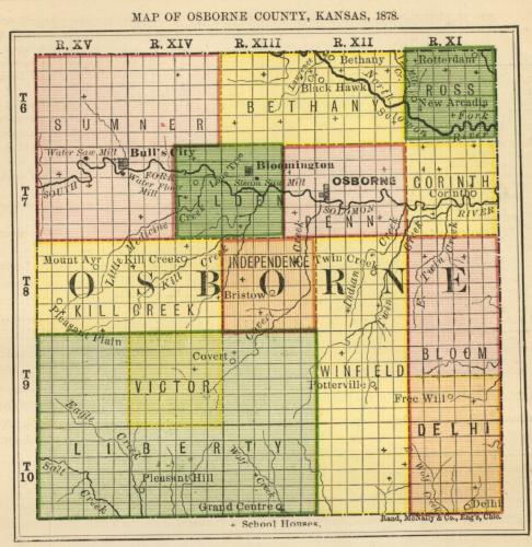
1878 Osborne County
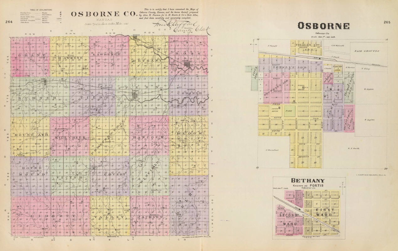
1887 Osborne County
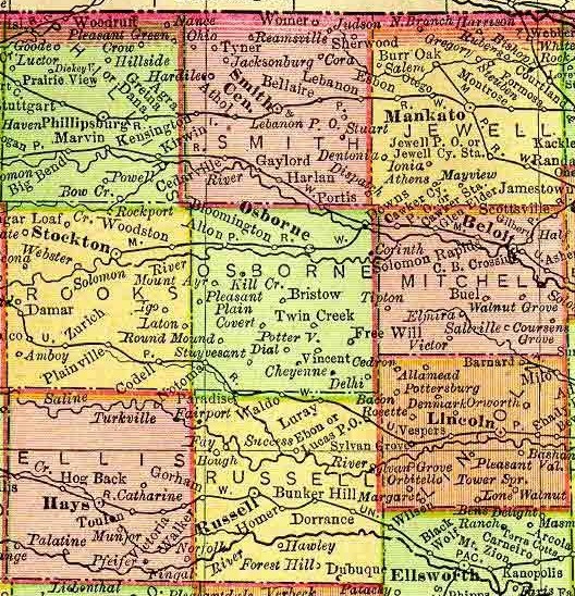
1895 Rand McNally Atlas
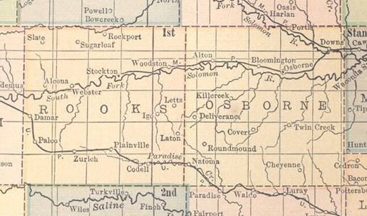
1914 Atlas
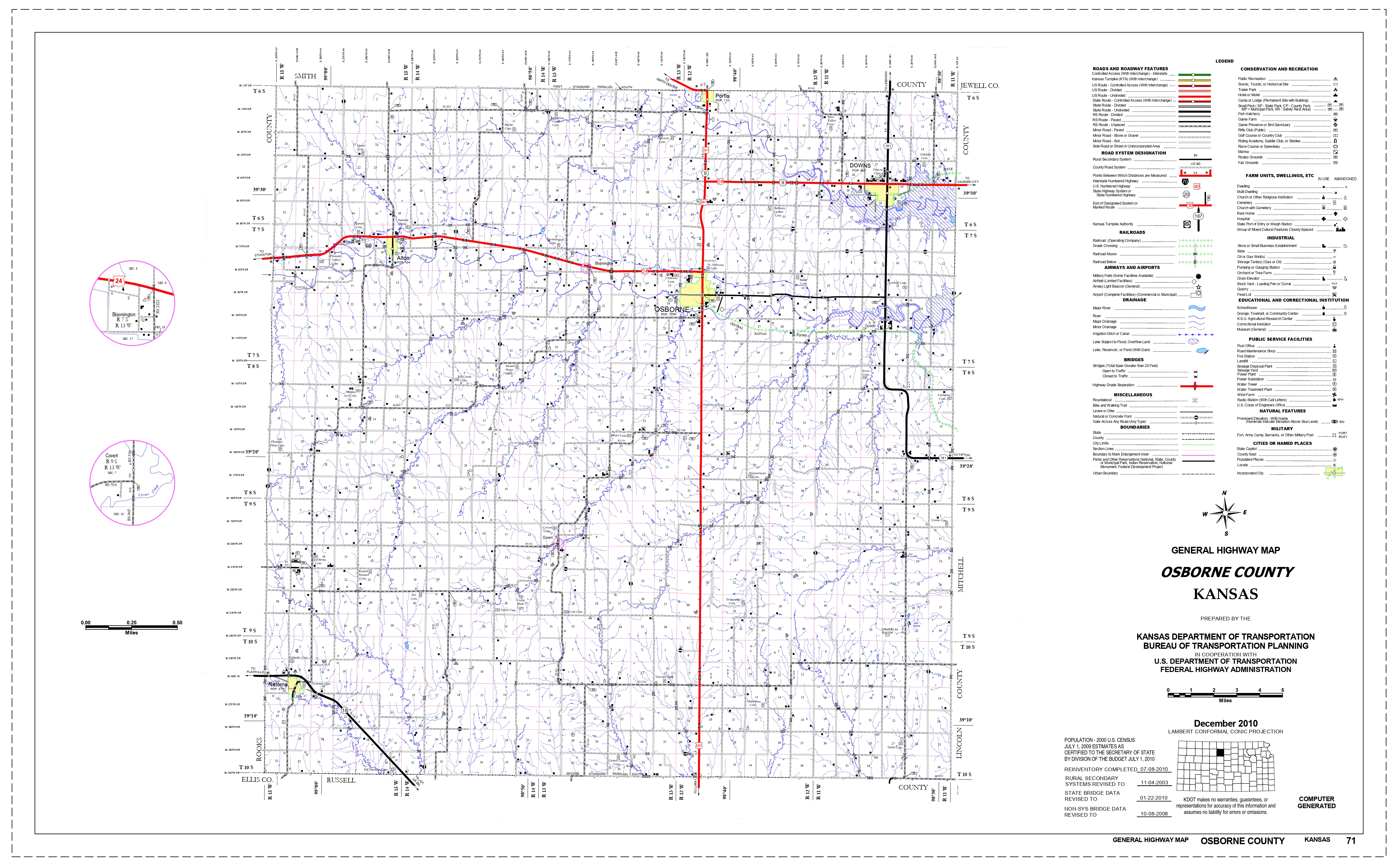
2010 Kansas Dept. of Transportation
Alton, an incorporated town of Osborne county, is located on the Solomon river in Sumner township, and is a station on the Missouri Pacific R. R. 13 miles west of Osborne, the county seat. The population in 1910 was 414. Alton has a bank, a public library, a fire department, an opera house, a weekly newspaper, express, telegraph and telephone service, and is the principal shipping point and trading center for the northwestern part of the county. Extracted 2002 by Carolyn Ward from Kansas: A Cyclopedia of State History, volume I, page 66.
Banks ghost town
Bloomington, a village of Osborne county, is a station on the division of the Missouri Pacific R. R. that runs from Downs to Stockton, 5 miles west of Osborne, the county seat. It has a money order postoffice with one rural route, telephone connections, a hotel, some general stores, telegraph and express offices, and does some shipping. The population in 1910 was 88. Extracted 2002 by Carolyn Ward from Kansas: A Cyclopedia of State History, volume I, page 195.
Bristow, a rural hamlet in the central part of Osborne county, is about 10 miles southwest of Osborne, the county seat and most convenient railroad station. Extracted 2002 by Carolyn Ward from Kansas: A Cyclopedia of State History, volume I, page 234.
Cheyenne, a discontinued postoffice of Osborne county, is situated near the southeast corner, about 20 miles from Osborne, the county seat. Mail is received through the office at Luray by rural free delivery. Luray is the most convenient railroad station. Extracted 2002 by Carolyn Ward from Kansas: A Cyclopedia of State History, volume I, page 325.
Corinth
Covert, a village of Osborne county, is located on a creek of the same name about 15 miles southwest of Osborne, the county seat. It has a money order postoffice with one rural route, a daily mail hack running to Osborne, and is a trading center for the neighborhood. The population was 75 in 1910. Extracted 2002 by Carolyn Ward from Kansas: A Cyclopedia of State History, volume I, page 462.
Delhi (ghost town)
Deliverance, a small settlement in the western part of Osborne county, is located near the head of the Little Medicine creek, about 20 miles southwest of Osborne, the county seat. It is a trading center for that section of the county and in 1910 reported a population of 20. Alton is the nearest railroad station. Extracted 2002 by Carolyn Ward from Kansas: A Cyclopedia of State History, volume I, page 507.
Dial, a small hamlet of Osborne county, is situated in the Covert creek valley, about 15 miles southwest of Osborne, the county seat. Mail is received by rural delivery from the postoffice at Covert. Waldo, on the Union Pacific 6 miles south, is the nearest railroad station. Extracted 2002 by Carolyn Ward from Kansas: A Cyclopedia of State History, volume I, page 517.
Downs, an incorporated city of Osborne county, is situated in Ross township
on the Solomon river and at the junction of two lines of the Missouri Pacific R.
R., 10 miles east of Osborne, the county seat. The city owes its origin to the
construction of the Central Branch R. R., which was completed to this point in
1879. Downs was platted by John A. Beal and A. Z. Blunt in Aug., 1879, and the
following December the town was incorporated with the following officers: Mayor,
J. B. Craney; clerk, J. G. Poole; councilmen, John Parish, O. Denton, L. F.
Pennington, J. E. Kentzel and G. W. Howell. The railroad company made Downs a
division point and erected a roundhouse and repair shop, which gave the place an
impetus. On Feb. 9, 1880, Thomas G. Nicklin issued the first number of the Downs
Times, and in Aug., 1880, bonds were voted for the erection of a modern school
building. Churches and lodges of various fraternal orders were established, and
the growth of Downs has been steady and substantial from the start.
In
1910 Downs reported a population of 1,427, a gain of 489 during the preceding
ten years. The city is equipped with electric lights, a fire department,
waterworks, well kept streets, etc. It has 2 banks, an international money order
postoffice with three rural routes, express and telegraph service, a telephone
exchange, a public library, an opera house, 2 weekly newspapers (the Times and
the News), an ice and cold storage plant, flour mills, grain elevators, brick
and tile works, the railroad machine shops, good mercantile establishments, and
the professions are well represented.
Extracted 2002 by Carolyn Ward from Kansas: A Cyclopedia of State History,
volume I, pages 541-542.
Forney (ghost town)
Free Will (ghost town)
Handy (ghost town)
Natoma, one of the thriving incorporated towns of Osborne county, is located in the southwest part of the county, on the Union Pacific R. R. 25 miles southwest of Osborne, the county seat. It has numerous retail mercantile establishments, churches and schools, a bank, and a newspaper (the Independent). It was incorporated as a city of the third class in 1905, has telegraph and express offices, and an international money order postoffice with three rural routes. The population according to the census of 1910 was 407. Extracted 2002 by Carolyn Ward from Kansas: A Cyclopedia of State History, volume II, page 336.
Osborne, the county seat and largest town of Osborne county, is located north
of the center of the county, on the Missouri Pacific R. R. and on the south fork
of the Solomon river. It has a public waterworks, fire department, opera house,
public library, 3 hotels, 3 banks, 6 churches, high school, graded schools and 2
weekly newspapers (the Osborne County Farmer and the Osborne County News). A
stage runs daily to Covert. There are three wards in the city, which is supplied
with express and telegraph offices, and has an international money order
postoffice with four rural routes. The population in 1910 was 1,566.
Osborne was founded in May, 1871, by a party of 35 people from Pennsylvania,
with W. L. Bear as president of the colony. The postoffice was established on
July 1 with H. D. Markley as postmaster. The first newspaper was the Osborne
Times, established in 1873 by J. J. Johnson and F. E. Jerome. The first school
was taught by Miss Yates. The first birth was that of Walter Jerome in 1873. The
first church organizations were formed in 1871, and houses of worship were built
in the early '70s. The town was proclaimed a city of the third class by Judge A.
J. Banta in May, 1873. The citizens failed to organize a legal city government,
and in 1878 Judge Holt again decreed Osborne to be a city of the third class and
ordered an election, which resulted as follows: Mayor, J. W. Elliott; police
judge, A. Anderson; clerk, F. E. Leebrick; treasurer, A. N. Fritchey;
councilmen, R. G. Hays, E. Smith, J. M. Morgan, A. Smith and Z. T. Walrond. In
1878 a bridge was built across the Solomon at this point. A bank, which was a
branch of a Beloit banking house, was established soon afterward.
Extracted 2002 by Carolyn Ward from Kansas: A Cyclopedia of State History,
volume II, pages 417-418.
Portis, one of the incorporated towns of Osborne county, is located in Bethany township on the Missouri Pacific R. R. 8 miles north of Osborne, the county seat. It has a bank, a weekly newspaper (the Independent), 3 churches, good schools, and a number of well stocked retail establishments. The town became a city of the third class in 1905. It has telegraph and express offices, and a money order postoffice with two rural routes. The population in 1910 was 304. A trading post was located at this point in 1871, and the town was platted in 1873. The Portis Patriot, one of the first newspapers in this section of the state was started in 1872. The town was named in honor of the vice-president of the Missouri Pacific R. R. Extracted 2002 by Carolyn Ward from Kansas: A Cyclopedia of State History, volume II, page 489.
Potterville (ghost town)
Roundmound, a hamlet of Osborne county, is located on the eminence of that name, 21 miles southwest of Osborne, the county seat, and 5 miles northeast of Natoma on the Union Pacific R. R., the nearest railroad station and the postoffice from which it receives mail by rural route. Extracted 2002 by Carolyn Ward from Kansas: A Cyclopedia of State History, volume II, page 610.
Twin Creek, a country postoffice in Osborne county, is located in Winfield township, 11 miles south of Osborne, the county seat, which is also the nearest railroad station and shipping point. There is one general store and one rural mail route. The population in 1910 was 95. Extracted 2002 by Carolyn Ward from Kansas: A Cyclopedia of State History, volume II, page 823.
Vincent (ghost town)
Yoxall (ghost town)
Copyright © 1996 - The USGenWeb® Project, KSGenWeb, Osborne County

This page was last updated
06/30/2026