 At left:
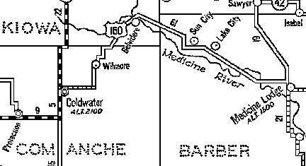
 Detail of a 1934 Map of Highway 160.
Collection of Phyllis Scherich.
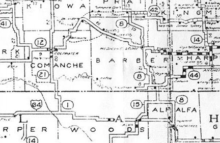
 Map at left: The Kansas State Highway System, John W. Gardner, Director, W. V. Buck, State Highway Engineer. 1928.
The legend on the map shows this road as "Unimproved (Earth)". On this map it is labeled as "12". The broken line road connecting Wilmore to Sun City was labeled as "Earth (County Road Connections)". Collection of Phyllis Scherich.
 At left:
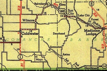
Detail of a 1934 Map of Highway 160.
Collection of Phyllis Scherich.
 Map at left: 1936 Phillips Petroleum map of Kansas, detail showing Comanche County.
Collection of Phyllis Scherich.
Note by Phyllis Scherich, 2004: "This is the first map that had this location labeled "Arrington" that I have seen. The location was the camp of Jesse Evans, then the site of the headquarters of the Comanche Pool from 1878 to 1886. After the Pool was dissolved it remained as the small town of Evansville, named after Jesse Evans, one of the organizers and large owners in the Pool. Later it ceased to exist as a town, but served as headquarters for Mortimor Platt�s Ranch, the Arrington Ranch, then the West Ranch of Davis, Nolan, & Merrill Grain Company. Since the early 50�s it has been the Merrill Ranch headquarters. There are currently three occupied homes at the site, with a population of 8."
U.S. Highway 160 has recently been designated as the Gypsum Hills Scenic Byway by the Kansas Department of Transportation and the Federal Highway Administration through the Kansas Scenic Byways Program.

Above:Topographical map of Highway 160 from Coldwater (at left) to Medicine Lodge (at right).
Also see: 2003 Map: Hwy 160 From Coldwater to Medicine Lodge

Highway 160 between Coldwater and Medicine Lodge, Kansas, looking east. Photo by Phyllis Scherich, 2003.

From C. J. Binning Studio, Medicine Lodge. Photo probably taken by Homer Venters of Lake City - see his write-up in Barber County History Book. Negatives supplied by John Nixon of Medicine Lodge to Phyllis Scherich.
The envelope they were in is labeled "Road from M. L. to Coldwater" BUT the date on the envelope is Nov. 9, 7 PM, 1926- before 160 was commissioned. Perhaps this was not the original envelope they were in and the label "160 highway" was added later when sorting negatives (only the 4 negatives were in the envelope.)
Thanks to Bobbi Huck for printing these black & white negatives!
At left: The Rockefeller Ranch near Belvidere, Kiowa County, Kansas, along the old route of Highway 160. Image from a postcard circa 1910."There were three divisions of the ranch as follows: The south house where Mr. and Mrs. Dan Gillet lived, the middlehouse where my husband and I lived, it was a nice new 5 room house so had plenty of room and was located right by the creek. I could go out and fish so did catch some nice ones. And the house up on the north side. I have forgotten the name of the people who lived there. In later years my brother Joe and his wife lived there so had three bothers working at the ranch. They had a zoo and had many wild birds and animals there. Also had buffalo but they were in a pasture to themselves. There were plenty of sight seers there on Sunday as there were quite a lot of things to see such as a fine herd of thoroughbred cattle." -- Christina Griffin: Early days on the Frank Rockfeller Ranch in the summer of 1902, Belvidere, Kansas
At left:The Rockefeller Ranch near Belvidere, Kiowa County, Kansas, along the route of old Highway 160, from an old postcard."We went to work in the spring of 1902. I helped cook for some of the men as there were about 40 men working there at that time. Some of the men were married so they would board some of the workers and the rest would board with the boss and his wife, Mr. and Mrs. Joe Pelton. We just got 15 cents per meal in those days. They were doing lots of building that year so they kept a carpenter and stone mason all the time as the large barns were mostly built of stone. Mr. George Hubert,Sr. was the stone mason and Mr. Stearman was the carpenter. I don't recall the wages they got but the ordinary help just received $20 per month. They had a large bunk house as they called it in those days and the hired help all slept there." -- by Christina Griffin: Early days on the Frank Rockfeller Ranch in the summer of 1902, Belvidere, Kansas
"It's been approximately 14 years now since the state highway commission promised the federal designating board that if they gave old K-12 the designation of US 160 the road would be straightened out. More than a decade has passed and the road is not finished." - Barber County Index editorial, January 11, 1940.
"My grandfather, John A. Lyons took this photo in 1925 on a family trip by car to visit relatives in Protection, Comanche County, Kansas." -- Connie Chancellor.
Though the location where this photo was taken is unknown, the road conditions are similar to those of old US 160 during wet times of the year.
The last remaining portion of the old Mule Creek Bridge on Highway 160, 27 April 2004.
Photo by Phyllis Scherich.
A ellipse culvert under Highway 160 in 2004. Highway 160 has this one, called the Little Ellipse, and another called the Big Ellipse. There are only a few culverts of this type in Kansas. You can tell from the picture that it was "formed" in place.
Photo by Phyllis Scherich.
"During the C.C.C. highway project to build Highway 160 from Coldwater to Medicine Lodge, Kansas, Dad (Ernest L. Ferrin) worked on the Mule Creek bridge in the winter of 1935/36. He drove a team of horses and feed wagon back and forth to work. He left home about 3:30 a.m. and returned about 10:30 p.m. He loaded the wagon with feed on the way home and fed the cattle the next morning on the way to work. I believe he got $3.00 a day for his team and himself". -- Wendel G. Ferrin, from Wendel Gene Ferrin: Life Stories, privately published.
Mineral Resources of Comanche County, The Western Star, February 18, 1938: "At least two deposits of volcanic ash occur in Comanche county. One of these is about 1 mile north of Wilmore and the other about 5 miles south of the same town. A small amount of material has been removed from these deposits and used in the construction of U. S. Highway 160."
1934 Map of Highway 160 2003 Map: Hwy 160 From Coldwater to Medicine Lodge
Copyright © 1996 -
The USGenWeb® Project, KSGenWeb, Comanche County
This page was last updated
11/21/2024