

Mitchell County
KSGenWeb

1883
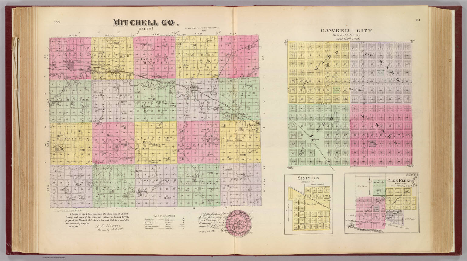
1887
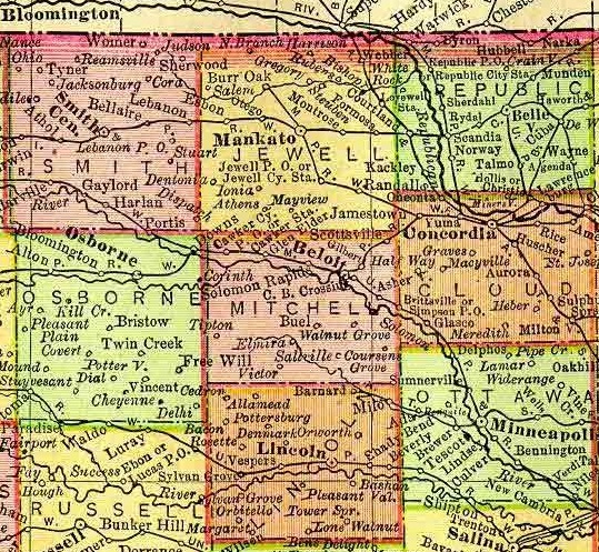
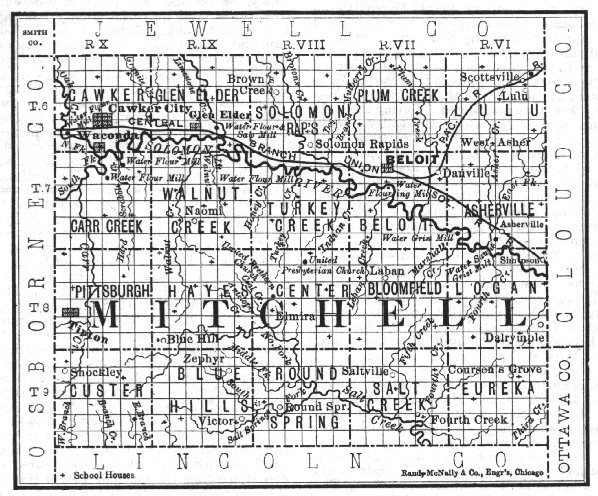
1895 Rand McNally Atlas
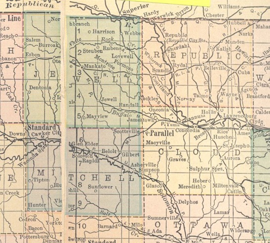
1914 Atlas
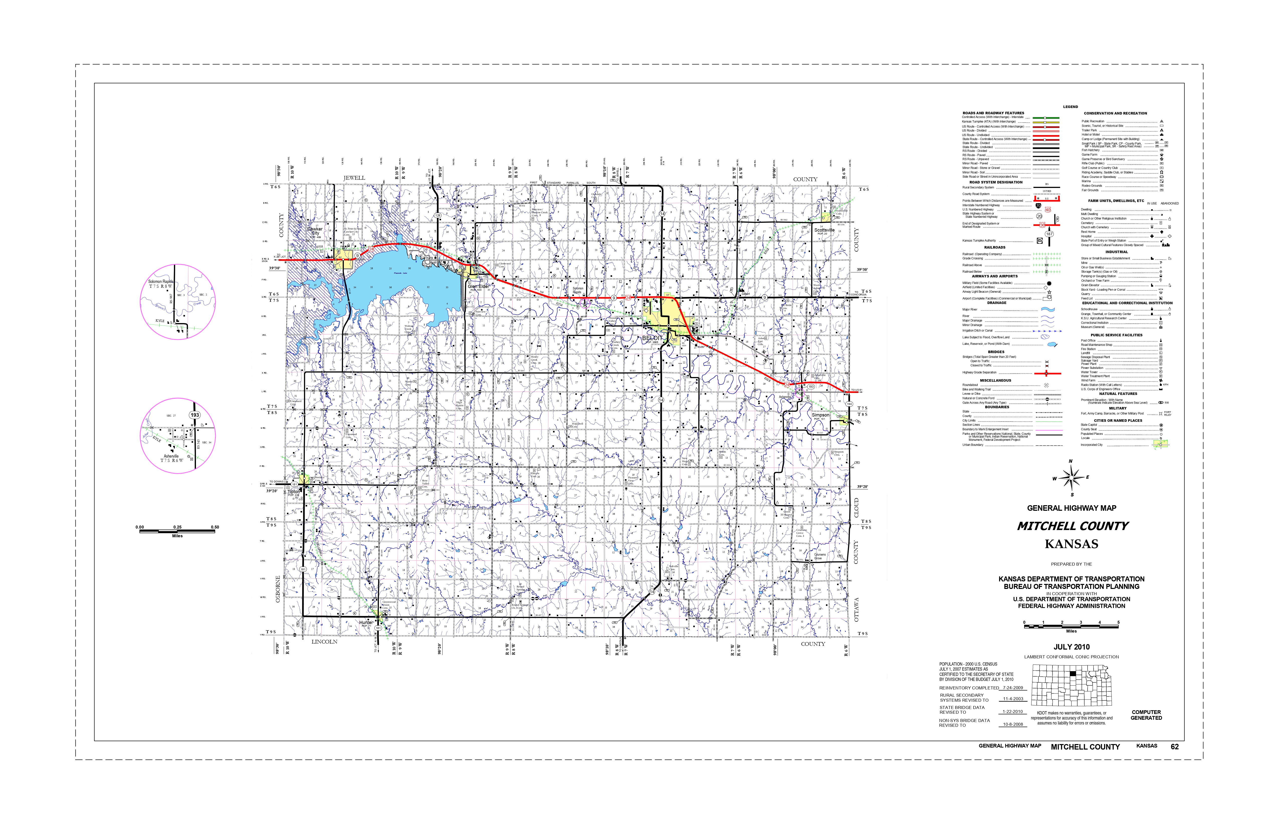
2010 Kansas Dept. of Transportation
Asherville formed in 1866
Beloit Township
Beloit City formed in 1866
Blue Hill Township
Bloomfield Township
Carr Township
Cawker City formed in 1871
Center Township
Custer Township
Eureka Township
Glen Elder formed in 1871
Hayes Township
Logan Township
Lulu Township
Pittsburg Township formed in 1872
Plum Creek Township
Round Springs Township
Salt Creek Township
Scottsville formed in 1878
Simpson (Brittsville) formed in 1882
Solomon Rapids
Turkey Creek
Walnut Creek

Contributed by Anne Fialcowitz
Asherville, one of the thriving little towns of Mitchell county, is located on the Solomon river and on the Union Pacific R. R. in Asherville township, 10 miles southeast of Beloit. It has a money order postoffice with one rural route, telegraph and express offices. The population in 1910 was 125. Asherville was the first postoffice in the county and also had the first store, established in 1867, by Hon. John Rees. Extracted 2002 by Carolyn Ward from Kansas: A Cyclopedia of State History, volume I, page 106.
Beloit, the county seat and largest town of Mitchell county, is located northeast of the center of the county, on the Solomon river and at the junction of the Union Pacific and Missouri Pacific railroads. It has an altitude of 1,381 feet and is 162 miles from Topeka. It has an electric light plant, water works, public library, an opera house, two daily and three weekly newspapers, 3 banks, and all lines of business activity. The state industrial school for girls is located here. Beloit is supplied with telegraph and express offices and an international money order postoffice with 8 rural routes. The population in 1910 was 3,082. The first settlement here was made by A. A. Bell in 1868, with the idea of improving the water power. It was first called Willow Springs. The next year T. F. Hersey purchased the mill site from Mr. Bell, put up a saw mill in 1870 and a grist mill the next season. A school building was erected in 1871 and Rev. O. N. Fletcher, the preacher of Ashville, took charge of the school which was the first in the county. In 1870 Beloit was made the county seat and has remained so ever since. The plat of the site was made in 1872. The promoters were T. F. Hersey, A. A. Bell, George Campbell, Alexander Campbell, C. H. Morrill, Edward Valentine, W. C. Ingram and Daniel Kepler. In July of that year it was incorporated as a city of the third class and in 1879 Gov. St. John proclaimed it a city of the second class. At the first city election the following officers were chosen: T. F. Hersey, mayor; W. C. Ingram, M. R. Mudge, H. H. Lyon, Joseph Baughman and J. R. Vaughn, councilmen. The town was growing very rapidly at this time. As each building went up and became ready for occupany a dance was held in it first, then a religious meeting, after which it was turned over to the owner for his use. The postoffice was established in 1870 with A. A. Bell as postmaster. The first newspaper was the Mirror, established in 1871 by A. B. Cornell. The first bank was opened in 1873 by F. H. Hart. Extracted 2002 by Carolyn Ward from Kansas: A Cyclopedia of State History, volume I, page 171.
Blue Hill, an inland postoffice of Mitchell county, is located on Salt creek in Hayes township, 16 miles southwest of Beloit, the county seat, and about 12 miles south of Glen Elder, the nearest shipping point. The population in 1910 was 15. Extracted 2002 by Carolyn Ward from Kansas: A Cyclopedia of State History, volume I, page 196.
Buel
Cawker City, the second largest town in Mitchell county, is located in Cawker township in the northwestern part of the county, near the junction of the north and south forks of the Solomon river and on the Missouri Pacific R. R. 18 miles west of Beloit, the county seat. It is an incorporated city of the third class, has a public library, an opera house, 2 banks, flour mill, a creamery, a grain elevator, 2 weekly newspapers (the Ledger and the Public Record), express and telegraph offices, and an international money order postoffice with four rural routes. The population in 1910 was 870. Cawker city was founded in 1870 by E. H. Cawker, J. P. Rice and R. G. F. Kshinka of Milwaukee, and John J. Huckle of Towanda, Pa. The first building was erected by F. H. Cawker. Mr. Huckle built a dwelling and then returned to Pennsylvania and brought out a colony of his neighbors. By June, 1870, a steam sawmill was in operation. The plat of the town was not recorded until 1871. The government located a land office here in 1872. In 1874 it was taken to Kirwin, which was more centrally located. The town was incorporated that year as a city of the third class and an election held, at which the following officers were chosen: Mayor, F. J. Knight; councilmen, A. Parker, D. A. Hauling, W. Woodmansee, P. Wolf and J. A. Pope; police judge, L. S. Tucker. Extracted 2002 by Carolyn Ward from Kansas: A Cyclopedia of State History, volume I, pages 300-301.
Coursens Grove
Elmira
Glen Elder, an incorporated town of Mitchell county, is located on the Solomon river and the Missouri Pacific R. R., in Glen Elder township, 12 miles west of Beloit, the county seat. It has 3 hotels, 2 grain elevators, 2 banks, a weekly newspaper, express and telegraph offices and an international money order postoffice with four rural routes. The population in 1910 was 565. The town was established in 1871 by Neve & Spencer, and called West Hampton. The Glen Elder postoffice, which was located half a mile north of this point, was moved and the town took the name of the postoffice. The promoters of the town built a large flour mill. The Mitchell County Key, a greenback paper, was started by George F. Daugerty, who printed it by hand with a roller. Extracted 2002 by Carolyn Ward from Kansas: A Cyclopedia of State History, volume I, page s 751-752.
Hunter, a country postoffice in Mitchell county, is located in Custer township in the southwest corner of the county, 25 miles southwest of Beloit, the county seat, and 16 miles from Lucas on the Union Pacific, the nearest shipping point. The population in 1910 was 50. Extracted 2002 by Carolyn Ward from Kansas: A Cyclopedia of State History, volume I, page 890.
Saltville, one of the inland hamlets of Mitchell county, is located on Salt creek in the southeastern part of the county, about 12 miles south of Beloit, the county seat, and 7 miles northwest of Barnard, from which place it receives mail by rural route. The population in 1910 was 25. Extracted 2002 by Carolyn Ward from Kansas: A Cyclopedia of State History, volume II, page 643.
Scottsville, one of the incorporated towns of Mitchell county, is located in Lulu township in the extreme northeastern corner of the county on the Missouri Pacific R. R., 10 miles from Beloit, the county seat. It has a bank, a weekly newspaper (the Advance), telegraph and express offices, and a money order postoffice with two rural routes. The town was platted in Oct., 1878, at the time the railroad was first extended to that point. The population in 1910 was 248. Extracted 2002 by Carolyn Ward from Kansas: A Cyclopedia of State History, volume II, page 656.
Simpson, an incorporated town of Mitchell county, is located on the Union Pacific R. R. and the Solomon river in Logan township, 12 miles southeast of Beloit, the county seat. It has a bank, a flour mill, telegraph and express offices, and a money order postoffice with two rural routes. The population in 1910 was 211. The town was founded in 1879 under the name of Brittsville, but the name was changed in 1882. Extracted 2002 by Carolyn Ward from Kansas: A Cyclopedia of State History, volume II, page 697.
Solomon Rapids, a station on the Missouri Pacific R. R. in Mitchell county, is located on the Solomon river, in Turkey Creek township, 5 miles west of Beloit, the county seat. It has a money order postoffice, and the population in 1910 was 50. This point was settled early in the history of the county and was at one time a town of considerable importance. Extracted 2002 by Carolyn Ward from Kansas: A Cyclopedia of State History, volume II, page 715.
Sunflower, one of the inland hamlets of Mitchell county, is located about 11 miles south of Beloit, the county seat, from which place it receives mail. The population in 1910 was 25. Extracted 2002 by Carolyn Ward from Kansas: A Cyclopedia of State History, volume II, page 789.
Tipton, a thriving little town of Mitchell county, is located in Pittsburg township, 21 miles southwest of Beloit, the county seat, and 14 miles south of Cawker City, the nearest shipping point. All the general lines of business are represented, including banking. It has a money order postoffice with one rural route. The population in 1910 was 200. The town was founded in 1872 by Fred Sackoff, W. A. Pitt and J. F. Steinberg, and was at first called Pittsburg. Many of the early buildings, some of which are still standing, were of stone. In the early '80s the name was changed from Pittsburg to Tipton, on account of the Pittsburg in Crawford county. Extracted 2002 by Carolyn Ward from Kansas: A Cyclopedia of State History, volume II, pages 808-809.
Victor, a post-hamlet of Mitchell county, is located in Blue Hill township, 18 miles southwest of Beloit, the county seat, and 16 miles north of Vesper, the nearest shipping point. It receives mail daily. The population in 1910 was 40. Extracted 2002 by Carolyn Ward from Kansas: A Cyclopedia of State History, volume II, page 845.
Walnut Grove
West Asher
Copyright © 1996 - The USGenWeb® Project, KSGenWeb, Mitchell County

This page was last updated
06/29/2026