Theory and fancy are good to build air castles and picture a paradise and Fairy Land. Facts and real existing realities are good to build up a new county, where happy homes can be made and surround by all that goes to make a prosperous and progressive Commonwealth. Here is to the county of Comanche - the home of the rustler and for the industrious home seeker, the county that has the best county seat town in all the new west and supports three other busy, bustling, business and booming towns. A county that ranks among the first for clear running streams and wells from five to fifty feet that are inexhaustable with a supply of cold, pure, crystal water. A county that her soil will produce like a river bottom and effected less by drouth or wet weather than any other on the continent. Comanche -- organized in 1885 and by the men of action who wield the plow, build the homes, schools, churches and towns it will continue in the world of progress, be sustained by the press and backed by the capitalist, soon to celebrate her anniversary when she ranks first among sunny Kansas counties in progess, wealth, population and happiness. Sound her praises, let the world know that Comanche is the young Chieftain of Kansas. Welcome the industrious settler, encourage those you have, discourage the speculator, speed the plow and possess the laurels.

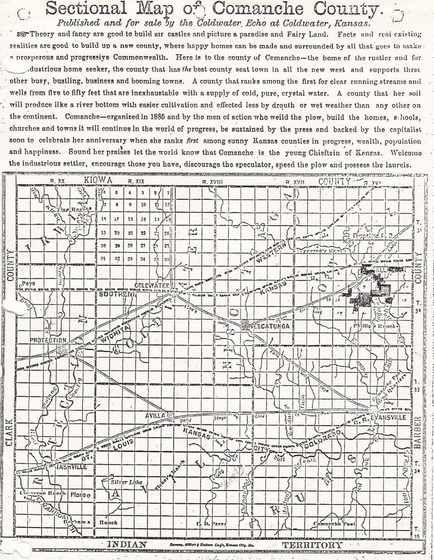
About this map: the exact date of publication is unknown, however, the Coldwater Echo was published from 5 Aug 1886 to 30 July 1891. Note that Wilmore isn't on the map, but that the location of the Pepperd Ranch where Wilmore would later be founded after 4 July 1887 when Cap Pepperd held a barbecue to promote the formation of the town is shown on the map.
Besides the Pepperd Ranch, the Phillips Ranch, Cimmaron Ranch, Graham's Ranch, Vickers Ranch and Comanche Pool Headquarters are shown. Cities and towns shown on the map are: Avilla, Coldwater, Evansville, Nescatunga, Plano and Protection.
Note the three railroad routes shown on the map; all were apparently speculative and only one railroad, the one labeled here as "Wichita Western", was ever built.
Also note the stagecoach routes shown on this map!
(As for the darkened areas seen above the Phillips Ranch, it appears that these were annotations made by some user of the map.)
Also see:
Sectional Map of Comanche County, Kansas, 3 May 1887. Published in The Kansas Ledger, Protection, Kansas. Courtesy of Shirley Brier.
1892 USGS Topographical Map of Comanche County, Kansas. Collection of Eugene Markstrom.
1934 Map of Highway 160. Collection of Phyllis Scherich.
1936 Phillips Petroleum Map of Kansas, detail of southwestern Kansas area. Collection of Phyllis Scherich.
1936 Phillips Petroleum Map of Kansas, detail of Comanche County area. Collection of Phyllis Scherich.
Map of Present and Past Cities & Towns in Comanche County, Kansas.
2003 Topographical Map: Hwy 160 From Coldwater to Medicine Lodge
Thanks to Phyllis Scherich for contributing the above map from her collection to this web site!
Copyright © 1996 -
The USGenWeb® Project, KSGenWeb, Comanche County
This page was last updated
11/24/2024