COMANCHE COUNTY KSGENWEB 2008: HISTORY & GENEALOGY

HOME     Bibliography     Biography     Cemeteries     Churches    Cities & Towns     Clubs     Contributors     Diamond Jubilee     Events     FAQ     Genealogy     Guest Book     History     Links     Maps     Military     News Articles     Newspapers     Opry     Photos     Poetry     Records     Satellite Images     Schools


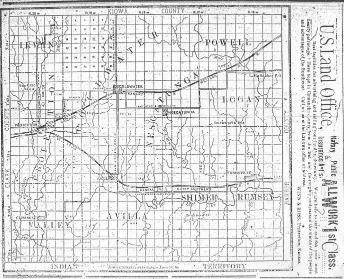
Map of Comanche County, Kansas, 3 May 1887

Map of Comanche County, Kansas, 3 May 1887.

From 'Kansas Weekly Ledger', May 3, 1887. (Published at Protection, Kansas.)

Scan courtesy of Shirley Brier.
Map of Comanche County, Kansas, published 3 May 1887
This map was published at Protection, Kansas, in the Kansas Weekly Ledger in both April and May, 1887.
An original copy of this map may be available in the Comanche County courthouse.
The railroad shown above Shimer and Rumsey townships was never built.
Scan courtesy of Shirley Brier.

Caption - Map of Comanche County, Kansas, 3 May 1887.

From 'Kansas Weekly Ledger', May 3, 1887. (Published at Protection, Kansas.)

Scan courtesy of Shirley Brier.
Caption - Map of Comanche County, Kansas, published 3 May 1887
Scan courtesy of Shirley Brier.


Also see:

Sectional Map of Comanche County, Kansas, circa 1886. This map shows stage coach routes in the county! Collection of Phyllis Scherich.

Map of Present and Past Cities & Towns in Comanche County, Kansas.

1892 USGS Topographical Map of Comanche County, Kansas. Collection of Eugene Markstrom.

1934 Map of Highway 160. Collection of Phyllis Scherich.

History of Highway 160 for a 1928 map of the Kansas State Highway System and a detail of a 1934 Map of Highway 160. Collection of Phyllis Scherich.


Copyright © 1996 - The USGenWeb® Project, KSGenWeb, Comanche County
This page was last updated 11/24/2024