Maps and text transcribed from: Transactions of the Kansas State Historical Society, 1903-1904; edited by Geo. W. Martin, Secretary. Vol. VIII. Topeka: Geo. A. Clark, state printer, 1904.
Reproduced with permission of the Kansas State Historical Society.
The first territorial legislature, held in 1855, passed three acts relative to
the establishment of counties in the Territory of Kansas.
The first of these defined the boundaries of thirty-three counties. As the
survey had at that time only been begun, the definition was made by distances
only, the starting point being the main channel of the Kansas river at the point
where it crosses the Missouri line. The counties established by this act were
Johnson, Lykins, Linn, Bourbon, McGee, Douglas, Franklin, Anderson, Allen, Dorn,
Shawnee, Weller, Coffey, Woodson, Wilson, Richardson, Breckinridge, Madison,
Greenwood, Godfroy, Davis, Wise, Butler, Hunter, Doniphan, Atchison,
Leavenworth, Brown, Jefferson, Nemaha, Calhoun, Marshall, and Riley. (Laws of
1855, pp. 205-211.)
In most of these counties the population was not large enough to justify
organization, so the system of attaching the thinly inhabited counties to those
able to maintain an organization was adopted, the counties being organized, when
they had acquired the requisite population. The counties organized at the time
of establishment were Allen, Anderson, Atchison, Bourbon, Doniphan, Douglas,
Davis, Jefferson, Johnson, Leavenworth, Lykins, Linn, Madison, Marshall, Nemaha,
Riley, and Shawnee. For civil and military purposes, Weller and Richardson were
attached to Shawnee; Butler, Wise and Breckinridge to Madison; Coffey to
Anderson'; McGee to Bourbon; Greenwood, Hunter, Dorn, Wilson, Woodson and
Godfroy to Allen; Brown to Doniphan; Davis to Riley (id., pp. 210-215)..
The second act of 1855 created two new counties: Marion, out of a tract of land
one hundred miles long and eighteen wide, west of Hunter, Butler and the south
half of Wise; and Washington, including all the part of territory west of Marion
and east of a line drawn north from the northeast corner of New Mexico. Both
counties were attached to Allen (id. p. 214).
The third act created Arapahoe county out of all that part of the territory west
of the line running north from the northeast corner of New Mexico (id. p. 217).
Commissioners were appointed, but the organization seems not to have been
completed, for in the same session an act, providing for an annual election of a
delegate to the territorial assembly, attached the county to Marshall. This act
further provided that all territory west of Marshall and east of Arapahoe should
be attached to Marshall, and all territory west of Riley and east of Arapahoe
should be attached to Riley* (id. pp. 218,219).
* For origin of county names as they exist
today, see seventh volume, pages 472 to 474. The following gives the origin of
the names that have disappeared, as near as possible to discover:
ARAPAHOE.- For the Plains tribe of Indians.
BILLINGS.- For N. H. Billings, a resident of Norton Center, and representative
from the 100th district, legislature of 1873, changed to Billings in jest, and
restored to Norton by the next session.
BRECKINRIDGE. - For John Cabell Breckinridge, vice-president of the United
States with President Buchanan, a native of Kentucky, 1821-1875; presidential
candidate in 1860 of the slaveholding interest.
BRODERICK. - For David Colbreth Broderick, elected United States senator for
California in 1856, served 1857-'59, when he was shot in a duel by Judge David
S. Terry. He was an eminent debater and opposed the admission of Kansas under
the Lecompton Constitution. He became separated from the Democratic party on the
slavery question in 1868.
BUFFALO. - For the bison of the plains.
CALHOUN. - For John Calhoun, first surveyor general of Kansas. See this volume,
p. 1, foot-note.
DAVIS. - For Jefferson Davis, president of the Southern Confederacy.
DORN.- For Andrew J. Dorn, United States agent for the Osages, Quapaws, and
united nations of the Senecas and Shawnees, at the Neosho Indian Agency, Kansas,
July, 1853 to 1861, when he was succeeded by P. P. Elder of Ottawa.
EL PASO. - Spanish "The Passage," "the gap."
FREMONT. - For John Charles Fremont, the western explorer and Union general,
nominated by the first national Republican convention, Philadelphia, for
president June 17, 1856. Born, 1813, died, 1890.
FOOTE. - Probably for Andrew Hull Foote, 1806-1863, United States naval officer
war of the rebellion.
GARFIELD. - For James Abram Garfield, twentieth president of the United States,
1831-1881.
GODFROY, or " frey."
HAGEMAN.
HOWARD. - For Oliver Otis Howard, soldier and philanthropist, graduate of
Bowdin, 1850, West Point, 1854, brigadier general volunteers 1861; chief of the
Freedmen's Bureau, 1865-1874, because of his able services to secure to the
freedmen of this country their rights as freemen.
HUNTER. - Probably for Robert Mercer Taliaferro Hunter, United States senator
from Virginia, 1847-1861; opposed use of United States troops to enforce the
"Bogus" laws in Kansas; favored the repeal of the Missouri proslavery law making
a death penalty for certain offenses against the rights of slaveholders; favored
the admission of Kansas under the Lecompton constitution; candidate for
president before the national Democratic convention of 1860.
IRVING. - For the poet, Washington Irving.
KANSAS. - For the Kansas tribe of Indians.
LYKINS. - For David Lykins, a member of the Territorial Council of 1855, from
the fourth council district, and at the time superintendent of the Wea Mission
for the Weas, Piankeshaws, Peorias, and Kaskaskias. His post-office was
Westport, occupation physician, and age 34 years, nativity Iowa. He had been
connected with the Baptist Mission among the Pottswatomies in 1853, and was
given the title of "reverend" by the agent.
MADISON. - For James Madison, fourth president of the United States.
McGEE. - For Mabillon W. McGee, member of the Kansas territorial house of
representatives, 1855, with post-office at 110 Crossing, Weller (Osage) county.
He was a merchant of Westport, Mo., who took a claim near Burlingame, but did
not stay long in Kansas. He was born in Kentucky in 1818, and was a brother of
Fry P. McGee of Osage county.
MONTANA. -
ORO. -
OTOE. - For the Otoe Indians of Nebraska.
PEKETON. - Probably of Indian origin.
RICHARDSON - For Wm. P. Richardson, senator from the eighth council district,
legislature of 1855 and 1857; a native of Kentucky, 53 years of age in 1855.
August 31, 1855, he was commissioned major-general of the northern division of
the militia of Kansas Territory. Although a prominent actor of the proslavery
party, he wrote a letter deprecating the insult offered Governor Geary by W. T.
Sherrard in the territorial house of representatives in February 1857. His death
occurred on the 14th of the same mouth. Sub-agent Great Nemaha sub-agency, for
the Iowas, Sacs and Foxes, 1842-1846,
SHELBY. - For Joseph Orville Shelby, a native of Lexington, Ky., 1831, removed
to Waverly, Mo., in 1850. He participated in several of the raids during the
border troubles in Kansas. He served under General Price in the confederate
cavalry, organized Shelby's brigade and distinguished himself at Shiloh. At the
close of the war he marched his brigade to the service of Maximillian; died in
1897.
SHIRLEY.- For a young woman, in jest.
SEQUOYAH. - For Sequoyah (George Guess) the son of George Gist and a Cherokee
woman, born in 1770. Abandoned by his father, his mother reared him to industry
and trade. He had great mechanical ingenuity. By 1821 he had devised a syllabic
alphabet of 83 letters for the Cherokee language, which was adopted by his
nation.
ST. JOHN. - For John Pierce St. John, eighth governor of Kansas. (See this
volume, page 295, foot-note.)
WELLER.- Probably for John B. Weller, United States senator for California,
1852-'57, defeating John C. Fremont. He was governor of California 1858-'60.
WISE.- For Henry Alexander Wise, governor of Virginia, 1855-1859; about his last
official act as governor was the hanging of John Brown.
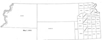
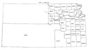
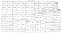
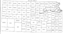
Map I, 1855
includes origin of county names
for those counties not existing in 1904. |
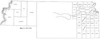
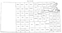
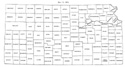
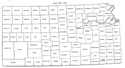
Map II, 1857-'59 |
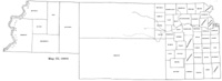
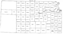
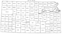
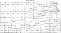
Map III, 1860 |
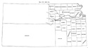
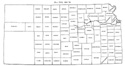
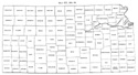
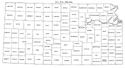
Map IV, 1861-1864 |
Map V, 1865-1866 |
Map VI, 1867 |
Map VII, 1868 |
Map VIII, 1869-1872 |
Map IX, 1873 |
Map X, 1874 |
Map XI, 1875-1880 |
Map XII, 1881, '82 |
Map XIII, 1883,'84 |
Map XIV, 1885 |
Map XV, 1886-1892 |
| |
Map XVI, 1893-1904 |
Article Introduction |
Return to top
Maps and text transcribed from: Transactions of the Kansas State Historical Society, 1903-1904; edited by Geo. W. Martin, Secretary. Vol. VIII. Topeka: Geo. A. Clark, state printer, 1904.
Reproduced with permission of the Kansas State Historical Society.
Background and KSGenWeb logo were designed and are copyrighted by
Tom & Carolyn Ward
for the limited use of the KSGenWeb Project.
Permission is granted for use only on an official KSGenWeb page.
©1999 - Tom & Carolyn Ward
