Maps and text transcribed from: Transactions of the Kansas State Historical Society, 1903-1904; edited by Geo. W. Martin, Secretary. Vol. VIII. Topeka: Geo. A. Clark, state printer, 1904.
Reproduced with permission of the Kansas State Historical Society.
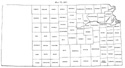
In 1861 that part of township 10 of range 8 lying in Davis county was
transferred to Riley (Territorial Laws of 1861, p. 16). Madison county
disappeared, its territory being divided between Breckinridge and Greenwood.
Greenwood received all south and Breckinridge all north of the line between
townships 21 and 22 (id. p. 17). The south line of Woodson was pushed twelve
miles north to the north line of the Osage lands (Session Laws of 1861, p. 107).
The name of Lykins county was changed to Miami, Dorn to Neosho and Godfroy to
Seward (id. p. 114). Greenwood county was organized the next year (Laws of 1862,
p. 443).
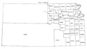
In 1864 Neosho county was organized. The eastern boundary of Morris county was
pushed four miles east to the line between ranges 9 and 10 east (Laws of 1864,
p. 48). Dickinson county was restored to its original form plus eight sections
from the eastern part of township 14, range 5 east, and the western boundary of
Davis was correspondingly modified (id. pp. 48, 49). Chase county was extended
south to the north line of township 93, and Butler county was enlarged so as to
include Irving, Otoe, and Hunter, and all other territory east of the sixth
principal meridian (id. p. 50).
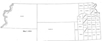
Map I, 1855
includes origin of county names
for those counties not existing in 1904. |
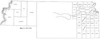
Map II, 1857-'59 |
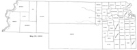
Map III, 1860 |
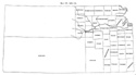
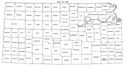
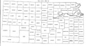
Map IV, 1861-1864 |
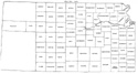
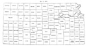
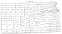
Map V, 1865-1866 |
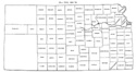
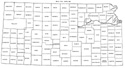
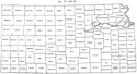
Map VI, 1867 |
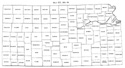
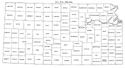
Map VII, 1868 |
Map VIII, 1869-1872 |
Map IX, 1873 |
Map X, 1874 |
Map XI, 1875-1880 |
Map XII, 1881, '82 |
Map XIII, 1883,'84 |
Map XIV, 1885 |
Map XV, 1886-1892 |
| |
Map XVI, 1893-1904 |
Article Introduction |
Return to top
Maps and text transcribed from: Transactions of the Kansas State Historical Society, 1903-1904; edited by Geo. W. Martin, Secretary. Vol. VIII. Topeka: Geo. A. Clark, state printer, 1904.
Reproduced with permission of the Kansas State Historical Society.
Background and KSGenWeb logo were designed and are copyrighted by
Tom & Carolyn Ward
for the limited use of the KSGenWeb Project.
Permission is granted for use only on an official KSGenWeb page.
©1999 - Tom & Carolyn Ward
