Maps and text transcribed from: Transactions of the Kansas State Historical Society, 1903-1904; edited by Geo. W. Martin, Secretary. Vol. VIII. Topeka: Geo. A. Clark, state printer, 1904.
Reproduced with permission of the Kansas State Historical Society.
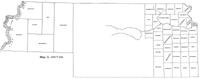
In 1886 Kiowa county was reestablished out of that part of Edwards south of the
north line of township 27 and that part of Comanche north of the sixth standard
parallel. (Laws of 1886, p. 54.) Stevens county was reestablished with the
same boundaries assigned to it in 1873, plus a strip three miles wide on the
western side of the county. Morton county was created out of the territory
which had been established as Kansas county in 1873, less the three-mile strip
given to Stevens. Seward was reduced to the limits assigned in 1873 (id., p.
57). The south boundary of Rice county was changed slightly, to include eight
sections of township 22, range 8, which were detached from Reno (id., p. 56).
The boundary between Lyon and Coffey was changed to the Neosho river for a
distance of sixty rods in township 20, range 13 east (id., p. 58).
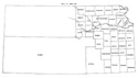
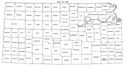
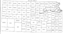
Gove, Hamilton, Kiowa, Lane, Morton, Scott, Seward, Sherman, Stevens, and
Wichita counties were organized in 1886.
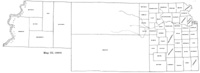
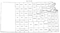
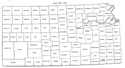
In 1887 the area of Finney, Hamilton and Ford counties was reduced. Haskell was
created out of that part of Finney which had been established as Araphaoe in
1873. Ford, Hodgeman and Hamilton again took the boundaries of 1873, and Grant,
Stanton and Kearny were reestablished with their former boundaries. Gray,
abolished in 1883, was reestablished with different boundaries. The north line
was now the north line of township 24, the east line the east line of range 27,
the south line the north line of township 30, and the west line the east line of
range 31. Garfield county was created out of six townships from the northeast
corner of Finney and six from the northwest corner of Hodgeman. (Laws of 1887,
pp. 111-113.) The name of St. John county was changed to Logan (id., p. 255).
Garfield, Gray, Haskell, Logan and Stanton counties were organized in 1887.
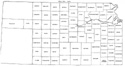
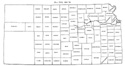
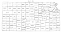
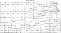
In 1889, the name of Davis county was changed to Geary (Laws of 1889, p. 182.)
In 1893 an act was passed providing for the restoration of the name Davis, in
case a majority of the voters should decide in favor of it at the next general
election (Laws of 1893, p. 88). The majority vote, however, was opposed to the
change, so that the county has retained the name of Geary.*
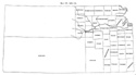
In 1889, the last of the counties - Grant, Greeley, and Kearny - were organized.
* The vote was taken at the general election
November 1894. The highest vote cast was 1686, but 475 did not vote on the
question of restoring the name to Davis. Of the votes cast upon the question,
there were 523 for Davis and 588 for Geary, being a majority of 65 for Geary, in
honor of John W. Geary, third territorial governor, a distinguished
major-general, and twice governor of Pennsylvania. This is probably the only
instance in Kansas of a name being adopted by a popular vote.
Map I, 1855
includes origin of county names
for those counties not existing in 1904. |
Map II, 1857-'59 |
Map III, 1860 |
Map IV, 1861-1864 |
Map V, 1865-1866 |
Map VI, 1867 |
Map VII, 1868 |
Map VIII, 1869-1872 |
Map IX, 1873 |
Map X, 1874 |
Map XI, 1875-1880 |
Map XII, 1881, '82 |
Map XIII, 1883,'84 |
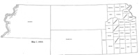
Map XIV, 1885 |
Map XV, 1886-1892 |
| |
Map XVI, 1893-1904 |
Article Introduction |
Return to top
Maps and text transcribed from: Transactions of the Kansas State Historical Society, 1903-1904; edited by Geo. W. Martin, Secretary. Vol. VIII. Topeka: Geo. A. Clark, state printer, 1904.
Reproduced with permission of the Kansas State Historical Society.
Background and KSGenWeb logo were designed and are copyrighted by
Tom & Carolyn Ward
for the limited use of the KSGenWeb Project.
Permission is granted for use only on an official KSGenWeb page.
©1999 - Tom & Carolyn Ward
