Maps and text transcribed from: Transactions of the Kansas State Historical Society, 1903-1904; edited by Geo. W. Martin, Secretary. Vol. VIII. Topeka: Geo. A. Clark, state printer, 1904.
Reproduced with permission of the Kansas State Historical Society.
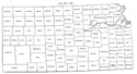
In 1875 Kiowa county was extinguished, its territory being divided between
Edwards and Comanche. Edwards was given all north of the north line of township
29, and Comanche all south of that line (Laws of 1875, p. 87).
By a similar act it was intended to obliterate Stafford county. Barton was to
receive that part north of the north line of township 24, and Pratt all south of
that line except townships 24 and 25 of range 15 west (id. p. 88). These two
townships, being left out of the division, preserved the identity of the county.
Four years later the supreme court declared this partition illegal and Stafford
county was restored to the boundaries assigned in 1874 (State V. St. John, 21
Kan. 591).
The line between Davis and Riley, south of the Kansas river, was changed to its
present position (Laws of 1875, p. 89). Howard county was divided into two new
counties. Elk comprised the part north of the north line of township 32 and
Chautauqua the part south of that line (id. p. 148).
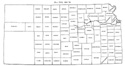
Republic county was organized in 1878.
In 1879 an act was passed redefining the boundaries of most of the western
counties but changing only Thomas, Sheridan, Wallace, Gove, and Lane (Laws of
1879, pp. 143-148). The south line of Thomas and Sheridan was pushed north six
wiles to the north line of township 10 (id. p. 143). Wallace was enlarged on the
north by a tract forty-two miles long and six wide, and on the east by a tract
thirty-six miles long and six wide. The west line of Gove was pushed 6 miles
east to the east line of range 30 west, the north line six miles north to the
north line of township 10, and the south line six miles north to the north line
of township 15. Lane county was enlarged by townships 15 in ranges 26-30 (id. p.
144). A few days after the passage of this act, but before its publication,
another act dissolved Wallace county on charge of fraud (id. p. 356.)
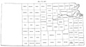
Decatur, Stafford, Hodgeman and Trego counties were organized in 1879.
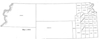
Map I, 1855
includes origin of county names
for those counties not existing in 1904. |
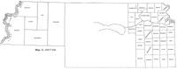
Map II, 1857-'59 |
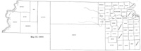
Map III, 1860 |
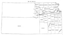
Map IV, 1861-1864 |
Map V, 1865-1866 |
Map VI, 1867 |
Map VII, 1868 |
Map VIII, 1869-1872 |
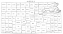
Map IX, 1873 |
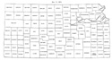
Map X, 1874 |
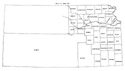
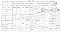
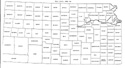
Map XI, 1875-1880 |
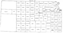
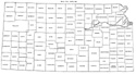
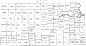
Map XII, 1881, '82 |
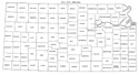
Map XIII, 1883,'84 |
Map XIV, 1885 |
Map XV, 1886-1892 |
| |
Map XVI, 1893-1904 |
Article Introduction |
Return to top
Maps and text transcribed from: Transactions of the Kansas State Historical Society, 1903-1904; edited by Geo. W. Martin, Secretary. Vol. VIII. Topeka: Geo. A. Clark, state printer, 1904.
Reproduced with permission of the Kansas State Historical Society.
Background and KSGenWeb logo were designed and are copyrighted by
Tom & Carolyn Ward
for the limited use of the KSGenWeb Project.
Permission is granted for use only on an official KSGenWeb page.
©1999 - Tom & Carolyn Ward
