Maps and text transcribed from: Transactions of the Kansas State Historical Society, 1903-1904; edited by Geo. W. Martin, Secretary. Vol. VIII. Topeka: Geo. A. Clark, state printer, 1904.
Reproduced with permission of the Kansas State Historical Society.
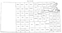
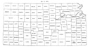
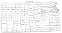
In 1868 two new counties - Gove and Wallace - were created. Shawnee, Jackson and
Brown took their final form, the line between Shawnee and Jackson being pushed
six miles north to the north line of township 10, and the line between Brown and
Jackson six miles north to the north line of township 5. (Special Laws, 1868,
pp. 49, 50.)
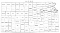
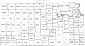
The general statutes of 1868 restated all county boundaries, and made some minor
changes. The line between Osage and Coffey was pushed three miles north to the
line between townships 18 and 19 (Statutes of 1868, p. 242). The line between
Woodson and Wilson was pushed two miles south, to the south line of township 26
(id. p. 248). The line between Greenwood and Howard was pushed nine miles north,
to the middle of township 28 (id. p. 236). A strip one mile wide, between the
north lines of townships 20 and 23, was added to Chase on the west (id. p. 231).
The act provided for an addition to Cherokee county on the west, in case the
legal voters in the proposed addition approved the change at the next general
election, but the question was not submitted, and the boundary remained
unchanged.
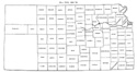
Two inconsistencies occur in the general act of 1868. The first is a merely
verbal error in the definition of Crawford county. "Twenty-four miles west from
the southeast corner of section 13, township 31, range 25 east to the eastern
boundary of Neosho county," should read "to the eastern boundary of Labette."
This error was corrected in 1874 (Laws of 1874, p. 104). The second occurs in
the boundaries of Wabaunsee and Shawnee counties. The triangle enclosed by the
Kansas river, the second standard parallel and an extension of the line between
Shawnee and Wabaunsee was included in both counties. This error was corrected in
1870 by giving the tract to Shawnee (Laws of 1870, p. 89).
Map I, 1855
includes origin of county names
for those counties not existing in 1904. |
Map II, 1857-'59 |
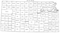
Map III, 1860 |
Map IV, 1861-1864 |
Map V, 1865-1866 |
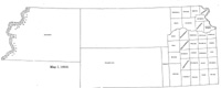
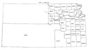
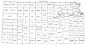
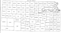
Map VI, 1867 |
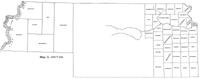
Map VII, 1868 |
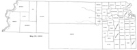
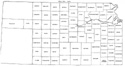
Map VIII, 1869-1872 |
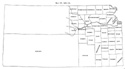
Map IX, 1873 |
Map X, 1874 |
Map XI, 1875-1880 |
Map XII, 1881, '82 |
Map XIII, 1883,'84 |
Map XIV, 1885 |
Map XV, 1886-1892 |
| |
Map XVI, 1893-1904 |
Article Introduction |
Return to top
Maps and text transcribed from: Transactions of the Kansas State Historical Society, 1903-1904; edited by Geo. W. Martin, Secretary. Vol. VIII. Topeka: Geo. A. Clark, state printer, 1904.
Reproduced with permission of the Kansas State Historical Society.
Background and KSGenWeb logo were designed and are copyrighted by
Tom & Carolyn Ward
for the limited use of the KSGenWeb Project.
Permission is granted for use only on an official KSGenWeb page.
©1999 - Tom & Carolyn Ward
