Maps and text transcribed from: Transactions of the Kansas State Historical Society, 1903-1904; edited by Geo. W. Martin, Secretary. Vol. VIII. Topeka: Geo. A. Clark, state printer, 1904.
Reproduced with permission of the Kansas State Historical Society.
In 1865 Douglas county took its final form by the acquisition of that part of
township 12, ranges 19 and 20, lying north of the river (Laws of 1865, p. 44).
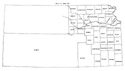
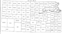
The west line of Greenwood county was pushed nine miles west to the center of
range 8 east, Butler county being thereby diminished by a strip nine miles wide
and thirty-three miles long (id. p. 45). Wilson county was given a tract on the
northeast two miles wide and twelve long, formerly belonging to Allen (id. p.
45). A verbal error in the definition of the boundary of Wilson county in this
act was corrected in 1867 (Laws of 1867, p. 47). The southern boundary of Allen
was pushed twelve miles north to the north line of the Osage Indian lands (id.
p. 46). Washington county was enlarged to include Shirley and Republic, with the
proviso that these counties should be restored whenever they acquired the
requisite population (id. p. 46). "Shirley" was printed "Shelby" in this act.
Marion county was enlarged to include Peketon* (id. p. 47).
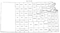
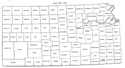
In 1866 Cherokee and Clay counties were organized and there was a slight change
in boundary lines. The eastern line of Neosho and the western line of Cherokee
was pushed two miles west, to a line drawn due south from the southeast corner
of Allen county (Laws of 1866, p. 78).
* The following letter appears among many
manuscripts deposited by Samuel N. Wood, and is the only mention the Society has
of Peketon county:
"KIOWA, PEKETON COUNTY, KANSAS, May 10th, 1864.
SIR: Yours respecting guerrillas and rebs., dated May 5th, received, Texians, or
"Te-han-nos," as the Indians call them, were reported on the way up through the
Indian country - some two or three weeks ago, and Kicking Bird, a Kiowa, assured
us that we might rely upon its being so, but as they showed no disposition to
move their families North, we paid no heed to it, although I am told they slept
upon their arms at the Fort. Yesterday Poor Bear and Lance, head chiefs of the
Apaches, were here, and informed us that a band of Comanches had scoured the
country S. W., S. & S. E. of us, and came into an Arapahoe village, some 20
miles below here for food, and report no "Tehannos." There is a report that the
Texians are going up the Cimarron. This I will believe as soon as I see the
squaws moving their lodges to Smoky Hill, but not before. The Kiowas and
Comanches, accompanied by a few Indians from other tribes, some 2 or 3 of J. I.
Delashmett's Kaws being of the number, numbering in all, as nearly as we can
learn, about 1000, are now about ready to make another bloody raid in Texas. The
Texians believe that our government sends them down, and if they should come up,
an event not improbable, as they are very desirous to punish the Indians, and
rob the trains on the road - a thing easily done, as the Forts at present afford
no protection whatever - then we and the I would all fare alike.
"Last week a runner came down with word that the Platte Indians, or Platte
Cheyennes, and the whites were fighting on Beaver - Black Kettle and Lean Bear
were here with bands numbering some 100 Lodges. They immediately pulled up and
struck out for the seat of war. The Cheyennes are much dissatisfied as to the
manner in which their "presents," or the goods Government gives them, are
withheld, and I would not be surprised if trains suffer on the road at any time.
George Bent, who is with the Cheyennes, told me a few weeks since that the Sioux
came amongst the Cheyennes last summer and agreed to come over and rob on the
road, but were prevented by his father. Chas. Rath is some 130 or 160 miles S.
W. trading with the Comanches; he left here April 23d, and will probably be
back in 8 or 10 days. His brother "Chris" left on the 12th of March with 2
wagons, one white man and one contraband, to trade with Cheyennes upon Smoky,
about 175 miles distant. He wrote home by an Indian about a month since, which
is the last tidings we received from him. The Indians say he will be here in 4
days. We are getting somewhat anxious about him.
. . . . . . . .
. .
May 11th, 1861. Chas. Rath has just got in from the Comanches, and reports all
Quiet in the Indian boundary.
Respectfully yours, &c., JOHN F. DODDS."
To Brig. Gen'I. S. N. Wood.
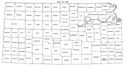
Map I, 1855
includes origin of county names
for those counties not existing in 1904. |
Map II, 1857-'59 |
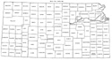
Map III, 1860 |
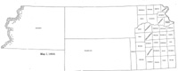
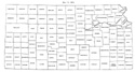
Map IV, 1861-1864 |
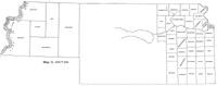
Map V, 1865-1866 |
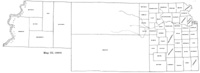
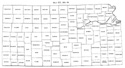
Map VI, 1867 |
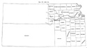
Map VII, 1868 |
Map VIII, 1869-1872 |
Map IX, 1873 |
Map X, 1874 |
Map XI, 1875-1880 |
Map XII, 1881, '82 |
Map XIII, 1883,'84 |
Map XIV, 1885 |
Map XV, 1886-1892 |
| |
Map XVI, 1893-1904 |
Article Introduction |
Return to top
Maps and text transcribed from: Transactions of the Kansas State Historical Society, 1903-1904; edited by Geo. W. Martin, Secretary. Vol. VIII. Topeka: Geo. A. Clark, state printer, 1904.
Reproduced with permission of the Kansas State Historical Society.
Background and KSGenWeb logo were designed and are copyrighted by
Tom & Carolyn Ward
for the limited use of the KSGenWeb Project.
Permission is granted for use only on an official KSGenWeb page.
©1999 - Tom & Carolyn Ward
