Maps and text transcribed from: Transactions of the Kansas State Historical Society, 1903-1904; edited by Geo. W. Martin, Secretary. Vol. VIII. Topeka: Geo. A. Clark, state printer, 1904.
Reproduced with permission of the Kansas State Historical Society.
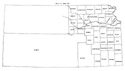
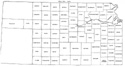
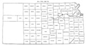
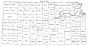
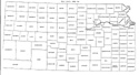
In 1867 Crawford, Ellis, Ellsworth and Labette counties were organized.
Thirty-five new counties were established, and several changes were made in the
boundaries of old ones.
The western boundary of Dickinson was changed to include the eastern half of
section 13, township 13, range 1 west (Laws of 1867, p. 49).
Labette county was created out of that part of the state south of the sixth
standard parallel and between the Osage reserve and the Cherokee neutral lands
(id. pp. 48, 49). This made the western boundary of Labette fall about two and
one-half miles west of the west line of Neosho, as formerly established. A
little later, Montgomery county was created out of that part of Wilson county
south of the sixth standard parallel (id. p. 51). With the establishment of this
county, the west line of Labette went back to the old line between Wilson and
Neosho, i. e., the line between the second and third tiers of Sections of range
17 east.
The south boundary of Bourbon was pushed six miles north to the section line two
miles north of the south line of township 24, and the north line of Cherokee was
pushed eighteen miles south to the middle of township 31. Out of the territory
thus detached from Bourbon and Cherokee the new county of Crawford was formed
(id. p. 50).
Another act provided for the division into counties of all the unorganized part
of the state east of range line 26 west; the counties to be organized when they
should have the requisite population. The counties created by this act were:
Montgomery, Howard, Cowley, McPherson, Sedgwick, Sumner, Jewell, Mitchell,
Lincoln, Ellsworth, Rice, Reno, Harper, Smith, Osborne, Russell, Barton,
Stafford, Pratt, Barbour, Phillips, Rooks, Ellis, Rush, Pawnee, Kiowa, Comanche,
Norton, Graham, Trego, Ness, Hageman, Ford, and Clark. By the same act Seward
disappeared, and the boundaries of Greenwood, Butler and Marion were changed.
Butler took its final form. The south line of Greenwood was pushed nine miles
south, to the north line of township 30. Marion was confined to one tier of
townships on the south, taken from Butler (id. pp. 51-57).
The name of Shirley was changed to Cloud (id. p. 68).
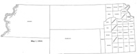
Map I, 1855
includes origin of county names
for those counties not existing in 1904. |
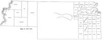
Map II, 1857-'59 |
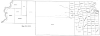
Map III, 1860 |
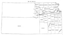
Map IV, 1861-1864 |
Map V, 1865-1866 |
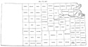
Map VI, 1867 |
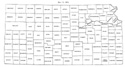
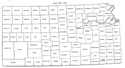
Map VII, 1868 |
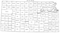
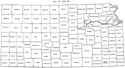
Map VIII, 1869-1872 |
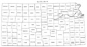
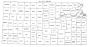
Map IX, 1873 |
Map X, 1874 |
Map XI, 1875-1880 |
Map XII, 1881, '82 |
Map XIII, 1883,'84 |
Map XIV, 1885 |
Map XV, 1886-1892 |
| |
Map XVI, 1893-1904 |
Article Introduction |
Return to top
Maps and text transcribed from: Transactions of the Kansas State Historical Society, 1903-1904; edited by Geo. W. Martin, Secretary. Vol. VIII. Topeka: Geo. A. Clark, state printer, 1904.
Reproduced with permission of the Kansas State Historical Society.
Background and KSGenWeb logo were designed and are copyrighted by
Tom & Carolyn Ward
for the limited use of the KSGenWeb Project.
Permission is granted for use only on an official KSGenWeb page.
©1999 - Tom & Carolyn Ward
